SW - W |
Brigsteer |
| Status : | OK | ||
| IMPORTANT - Restrictions on use | Maximum of eight gliders allowed. Not a recommended site for pilots less than Pilot (Hill) rated. Do not fly low over horses or the village whilst on landing approach. Do not take off on the Scar and do not block the entrance road or gate. No dogs. | ||
| Last Updated : | 20/04/2021 at 11:45 by John Westall | ||
| Last Reviewed : | 25/07/2017 by | ||
| Wind : | SW - W | ||
| Nil Wind : | No | ||
| Grid Ref : | SD488892 | Height (AMSL) : | 445' / 135m |
| Site Code : | 17.022 | Top to Bottom : | 430' / 131m |
Location
SE Lakes - W of Kendal
Details
A more extensive site than it at first appears with several miles of ridge and escarpment to fly. Conditions very much dictate the length of effective ridge. A once very popular and convenient site for HG. It has more recently become quite popular amongst the PG XC pilots. On take off the lift often only starts at the tree lined ridge at the lower edge of the field; this has then to be cautiously worked up onto the main scar.
Site Officer
John Westall : 07884 037144
Postcode for Sat Nav Systems (read the Health Warning!)
LA8 8AQ - This is the closest mail delivery point to the flying site and is positioned at:
Holeslack Farm. Satnav should guide you along the track past the church at SD488889 which is close to the take off area. If you get to the end point, you've gone too far.
Getting There
Approach from the east (A591) via a narrow, minor road which leads to just over crest of the hill. Alternatively, from the A590 via Levens to Brigsteer village then road up face of hill. A cattle grid on a sharp bend marks the entrance to the site.
Getting to takeoff
No walk involved. Usual to rig by or close to car.
Permission to use site
Take off field and bottom landing Field; although the site is National Trust land, the Take off and Bottom landing fields are farmed by Mr John Wilson of High House Farm.
Additional Safety Notes
Care on take off, especially if wind is off to the north. Check lie of power line across nearest landing field. Low flying military jets use the area midweek (NOTAM). Telephone in village by the (only) pub. Don't scratch close to trees!
The field from which we launch does suffer from harvest mites(Chiggers). You have been warned.
Paragliding
This site used to be rarely flown due to the shallow nature of the take off field, but in more recent years it has proven, in the right conditions to be very good. In fact this site now holds the accolade of being the launch pad for the longest distance flown from Cumbria. Despite the relative ease to go XC from here, it is not a location which is really suited for non thermic soaring and shouldn't be flown by pilots with less than Pilot rating!
The Fields directly below the take off area have now been officially negotiated as a bomb-out field useful for the PG pilot only. Please do not use them when the grass is getting ready for cutting as these are used as hay fields. These fields are useful in an emergency but should not be regarded as the main landing out option; the lower ones are undoubtedly the better.
Hang Gliding
A pleasant and interesting site to fly with the take off ranging from easy to, "I don't want to do that again!" Easy top landing but keep well back until familiar with the approach. Beware of small trees on the overshoot. Better thermal than ridge soaring site. If bottom landing try to pick a field without crop or stock; many are available adjacent to the road which crosses the plain in front of take off.
XC potential
Excellent. This is a good thermal site.
Photos
Click on the photo for a full size image.
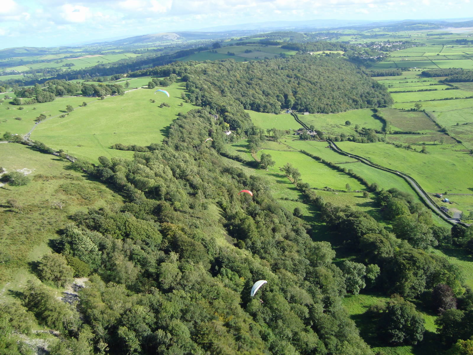
| Brigsteer from the north end, looking south. The Lyth valley is on the right. Take off is on the far left above the road crossing the bright green field. The bomb out field is immediately to the right of the wooded belt. You can see that the main take off field has a relatively gentle gradient. Photo by Roy Richards |
 |
Local Information - Pubs/Food etc
Nearest pubs to the site - for post flying debriefing only! You may find details of other facilities here
| Wheatsheaf, Brigsteer | |
| Grid Reference : | SD480896 |
| Distance from Site : | 0.6 miles |
| Notes : | This pub is at the bottom of the hill. It's a bit on the smart side but does good food. Weekends are busy and you will probably need to book for food. They have an interesting selection of local gins for after flight sampling! They have bunkhouse with rooms sleeping up to 4 people. The pub web site is here. |
| Click here to see the place in Google Street View | |
| Hare and Hounds, Levens | |
| Grid Reference : | SD484856 |
| Distance from Site : | 3.4 miles |
| Notes : | This pub is a bit further away and is a little more relaxed than the Wheatsheaf. It does really good food, including pizzas. In 2015, they had been doing a lot of work on refurbishment and have created a good atmosphere. gain this pub has accommodation - 4 bedrooms are available. The pub web site can be found here |
| Click here to see the place in Google Street View |
This page shows records for this site. Some of the older records are not very detailed. More recent records may have an igc file available You can right click and download this to your PC. You can then use IGC Flight replay to view the flight.
| Paragliding |
| Turnpoint Flight | |
| Distance : | 169.6km |
| Date : | 25/07/2009 |
| Pilot : | Mike Cavanagh |
| Notes : | 2 weeks after breaking the 100k barrier, Mike broke the 100 mile barrier in this flight to the east coast at Filey |
| IGC File : | Right click to download |
| Hang Gliding |
| Turnpoint Flight | |
| Distance : | 169.6km |
| Date : | 25/07/2009 |
| Pilot : | Mike Cavanagh |
| Notes : | 2 weeks after breaking the 100k barrier, Mike broke the 100 mile barrier in this flight to the east coast at Filey |
| IGC File : | Right click to download |
Data Resources
Follow the links to see the site in Google Earth and Google Street view. To access the former, you will need to have Google Earth installed on your PC. You can also upload your flights to GE - use GPS Dump (Links Page) to convert a variety of GPS file formats to a GE kml file.
| Link | Resource Type | Notes |
|---|---|---|
| Google Earth - Car Park | ||
| Google Earth - Car Park 2 | ||
| Google Earth - Sample Flight 1 | Kitt Rudd's Flight to Durham where he came close to breaking the 100km straight line distance | |
| Google Earth - Take Off | ||
| Google Street View - Parking | A good view of the take off area. Note the shallow angle of the slope! |
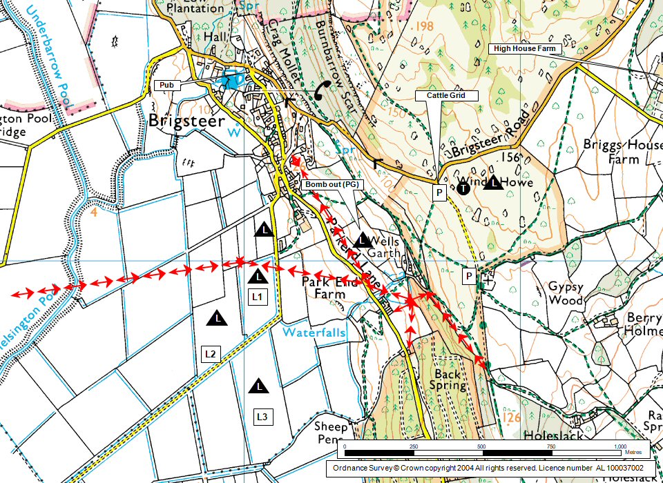
Brigsteer Map |
Legend |