SSE - SW |
Great Langdale |
| Status : | OK | ||
| IMPORTANT - Restrictions on use | Landing anywhere you like in the valley is NOT an option. Some of the farmers will be very unhappy if you land in their fields. Without a negotiated landing field there is to be NO flying. We do have very good landing options - please take the 10 mins to ask the relevant (and very friendly) farmers / landowners. While there is no specific restrictions due to lambing it is paramount to call in at Millbeck farm to agree which fields are to be used for landing. |
||
| Last Updated : | 01/04/2024 at 09:29 by John Westall | ||
| Last Reviewed : | 31/03/2021 by | ||
| Wind : | SSE - SW | ||
| Nil Wind : | Yes | ||
| Grid Ref : | NY285073 | Height (AMSL) : | 1706' / 520m |
| Site Code : | none | Top to Bottom : | 1410' / 430m |
Location
Central Lakes - W of Ambleside
Details
A rugged mountain site overlooking the beautiful Langdale valley set amongst the peaks of the Langdale Pikes.
Site Officer
John Westall : 07884 037144
Postcode for Sat Nav Systems (read the Health Warning!)
LA22 9JX - This is the closest mail delivery point to the flying site and is positioned at:
New Dungeon Ghyll Hotel, opposite car park
Getting There
From Ambleside, take the A593 to Skelwith Bridge. Turn right onto the B5343 through Chapel Stile and on to Langdale.
Getting to takeoff
From the parking areas in the Langdale Valley near to the New Hotel (NY 296065), make for Thorn Crag via the Stickle Ghyll footpath or the path running between Pike Howe and Dungeon Ghyll. Either route is steep and sustained. At Thorn Crag a decision can be made, according to the wind direction and strength, to take off here, in front of Stickle Tarn or to the left of Gimmer Crag.
Permission to use site
Anyone flying from the summits around the head of Great Langdale should contact Middle Fell Farm, next to the Old Dungeon Ghyll Hotel (NY 285061) AND/OR call at Millbeck (NY 296066)behind the New Dungeon Ghyll Hotel. They will generously advise on a suitable landing field specific to that farm.
Additional Safety Notes
This is a big site set amongst some of the bigger hills of the Lake District. This site is not for low airtime pilots. Be careful of a sea breeze that can set in and bring with it a rapid change in wind direction and turbulence. Some of the available landing fields have difficult to see telephone / power lines across them. Take extreme care on any landing approach.
Paragliding
This is a big site and if there is any appreciable wind in the valley then it is more than likely that it will be blown out at take off. Best in very light or nil wind conditions when the (large) thermals can form over the vast areas of scree and fellside. If tracking along the valley to the east then be aware of the restrictions on landing fields in the valley. If in doubt land well up on the fell side and walk down.
Hang Gliding
An almost impossible carry up.
XC potential
Excellent potential but the terrain is wild and demanding. There is the potential for a very long walk out if you have to land out.
Photos
Click on the photo for a full size image.
| Looking down from a paraglider to the eastern end of the Great Langdale take off area. Stickle Tarn is in the centre of the picture with Pavey Ark behind. The eastern flank of Harrison Stickle is in shadow. Stickle Ghyll and the main trade route up to the tarn are in the front of the picture. Picture by Pete Rycroft. |
 |
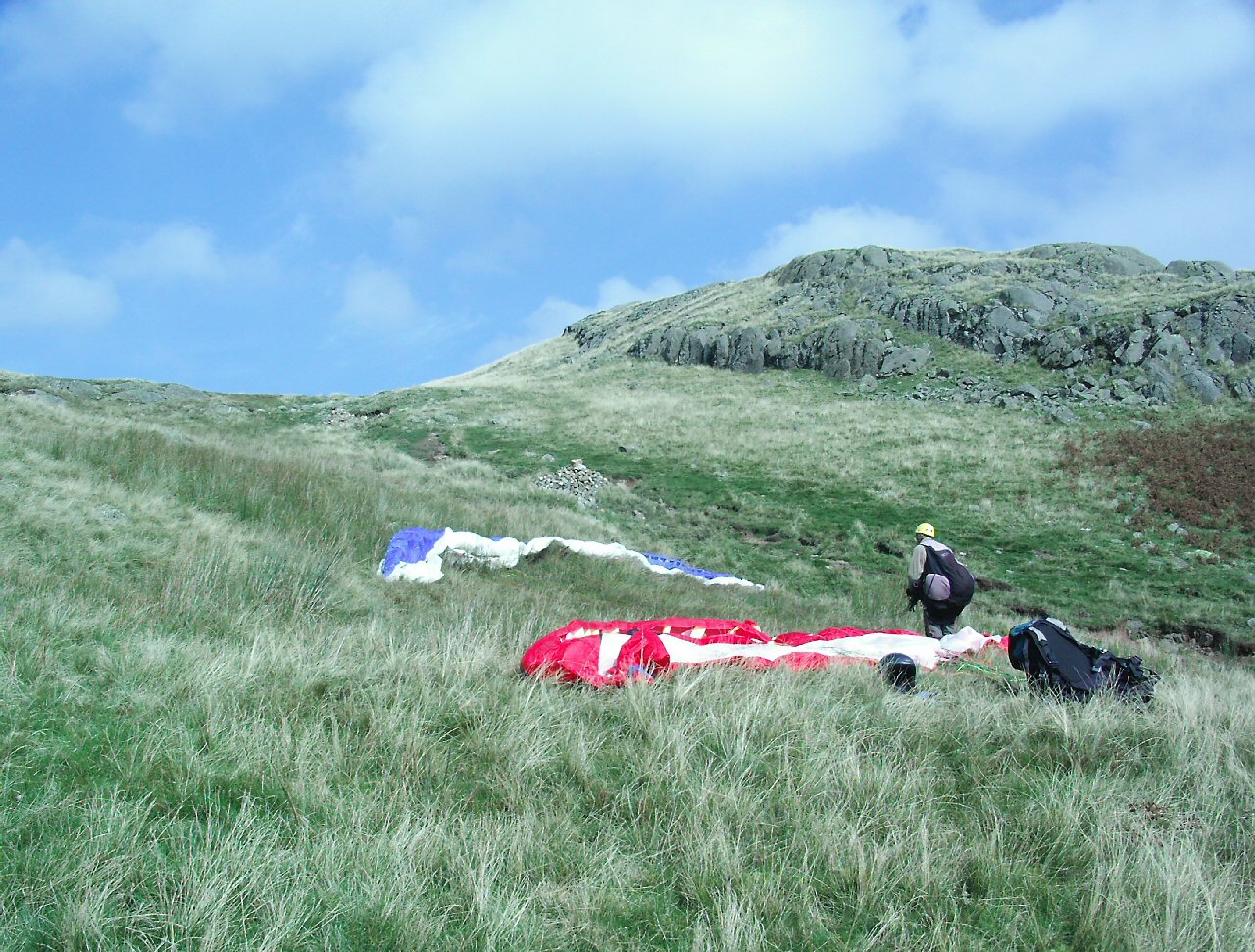
| Preparing for take off. Taken just below Stickle Tarn to the west of Stickle Ghyll. Picture by Pete Rycroft. |
 |
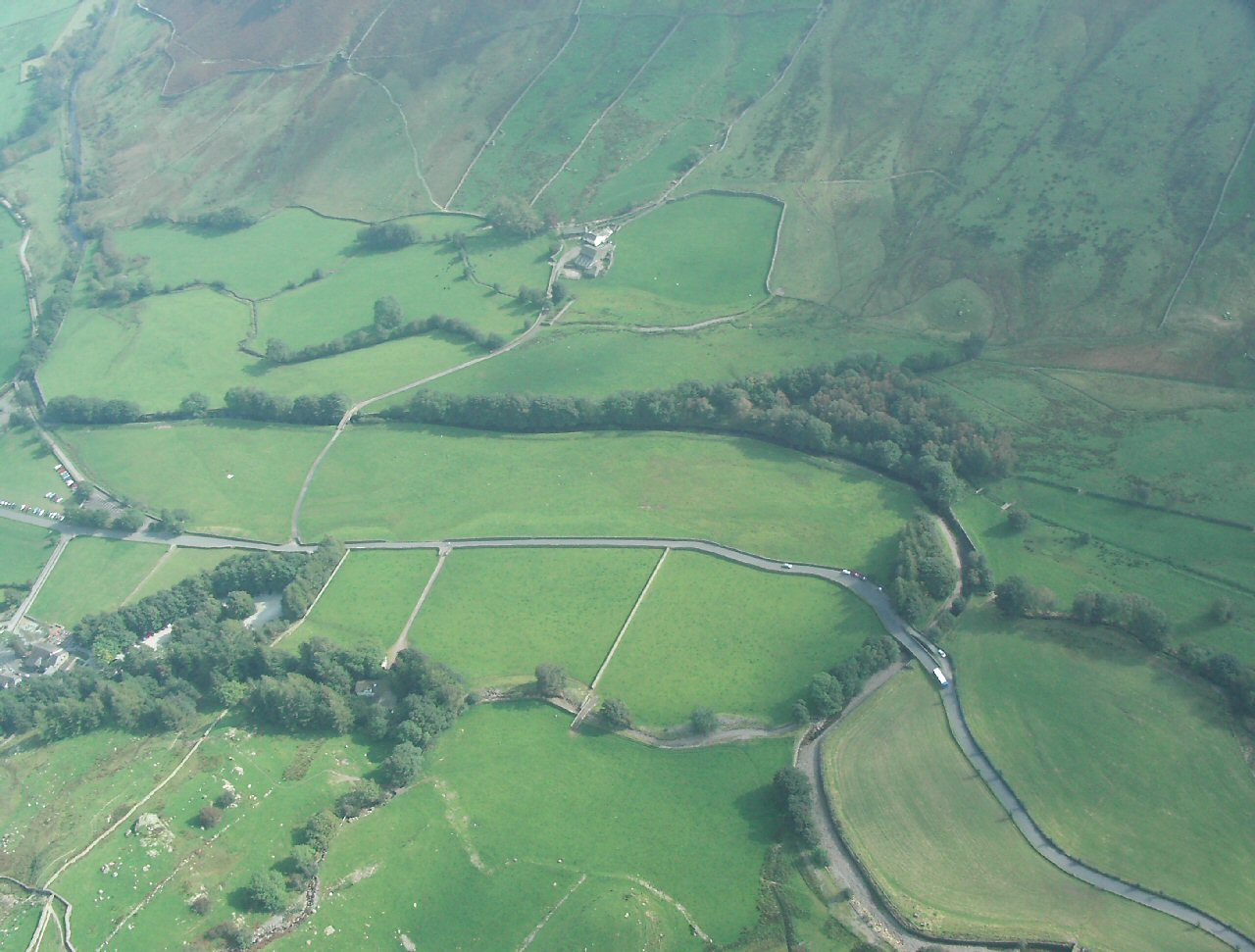
| Looking down on the landing fields. A glider can be seen in the eastern half of the landing field which is divided by a track to the farm at the top of the picture. A power line traverses the field which can be easily avoided; however, the landing field should be inspected before flying. Picture by Pete Rycroft. |
 |
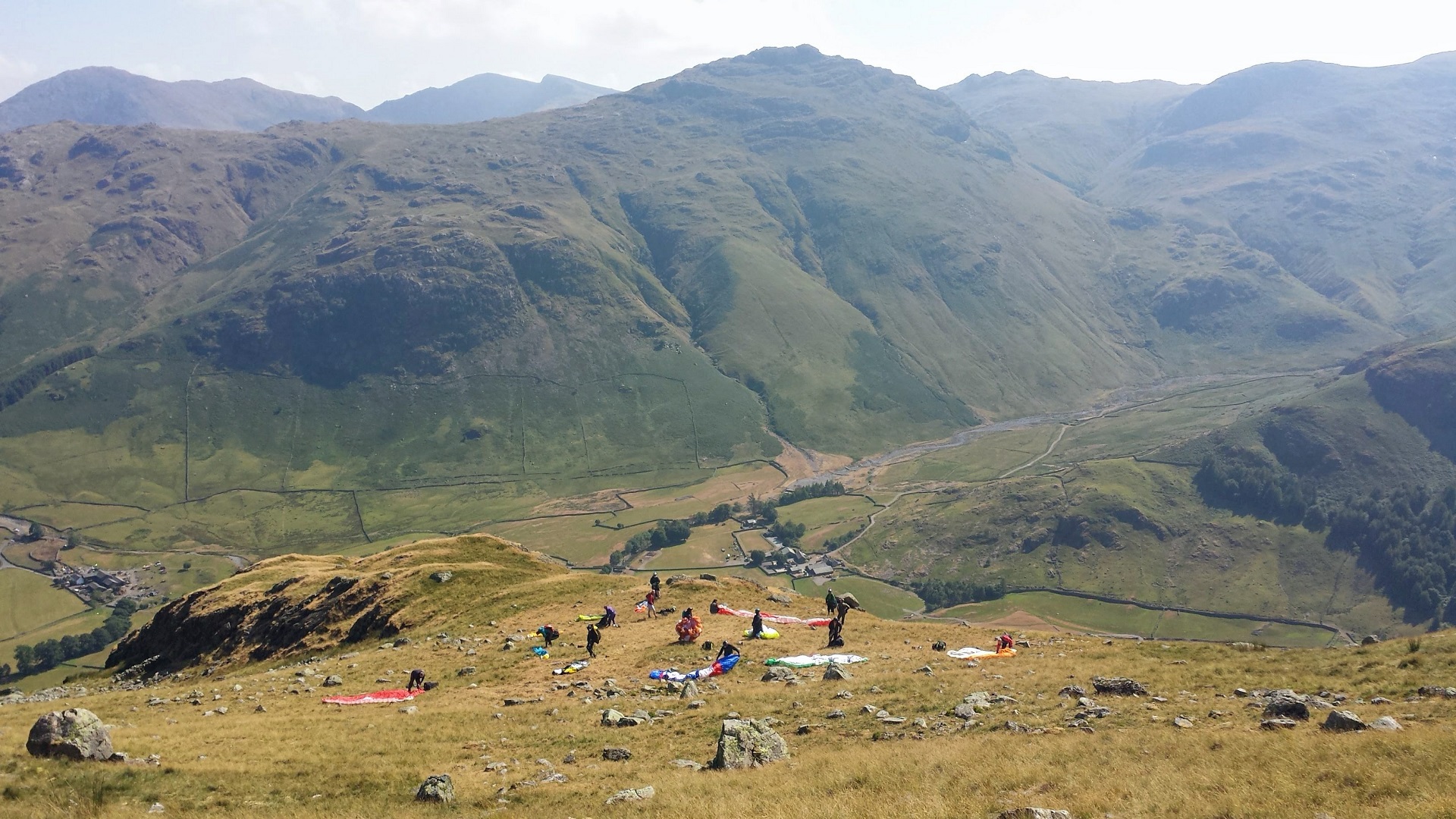
| Looking down at the take off used at the 2018 Lakes Charity Classic. Photo by Geoff Moss |
 |
Local Information - Pubs/Food etc
Nearest pubs to the site - for post flying debriefing only! You may find details of other facilities here
No pub details are available for this site. Send your recommendations to the webmaster.
This page shows records for this site. Some of the older records are not very detailed. More recent records may have an igc file available You can right click and download this to your PC. You can then use IGC Flight replay to view the flight.
| Paragliding |
| Declared FAI Triangle | |
| Distance : | 50.5km |
| Date : | 30/07/2011 |
| Pilot : | Mike Cavanagh |
| Notes : | |
| IGC File : | Right click to download |
| Open Distance XC | |
| Distance : | 70.2km |
| Date : | 19/05/2018 |
| Pilot : | Keith Paterson |
| Notes : | A flight from Great Langdale, north through the lakes and then NE to the A69 NW of Haltwhistle. Jaysen Metcalfe who started the flight with Bud says "It was very West on take off and the only way up seemed to be from a thermal from White Ghyll. Several of us landed in Grasmere into a strong south wind but Bud thermaled up low 200 ft up from the Travellers Rest up and along the ridge to Clough Head. We were all quite glad to land. As you can see from his track log he just skirted the Carlisle air space." |
| IGC File : | Right click to download |
| Turnpoint Flight | |
| Distance : | 81.6km |
| Date : | 19/05/2018 |
| Pilot : | Keith Paterson |
| Notes : | A flight from Great Langdale, north through the lakes and then NE to the A69 NW of Haltwhistle. Jaysen Metcalfe who started the flight with Bud says "It was very West on take off and the only way up seemed to be from a thermal from White Ghyll. Several of us landed in Grasmere into a strong south wind but Bud thermaled up low 200 ft up from the Travellers Rest up and along the ridge to Clough Head. We were all quite glad to land. As you can see from his track log he just skirted the Carlisle air space." |
| IGC File : | Right click to download |
| Hang Gliding |
| Declared FAI Triangle | |
| Distance : | 50.5km |
| Date : | 30/07/2011 |
| Pilot : | Mike Cavanagh |
| Notes : | |
| IGC File : | Right click to download |
| Open Distance XC | |
| Distance : | 70.2km |
| Date : | 19/05/2018 |
| Pilot : | Keith Paterson |
| Notes : | A flight from Great Langdale, north through the lakes and then NE to the A69 NW of Haltwhistle. Jaysen Metcalfe who started the flight with Bud says "It was very West on take off and the only way up seemed to be from a thermal from White Ghyll. Several of us landed in Grasmere into a strong south wind but Bud thermaled up low 200 ft up from the Travellers Rest up and along the ridge to Clough Head. We were all quite glad to land. As you can see from his track log he just skirted the Carlisle air space." |
| IGC File : | Right click to download |
| Turnpoint Flight | |
| Distance : | 81.6km |
| Date : | 19/05/2018 |
| Pilot : | Keith Paterson |
| Notes : | A flight from Great Langdale, north through the lakes and then NE to the A69 NW of Haltwhistle. Jaysen Metcalfe who started the flight with Bud says "It was very West on take off and the only way up seemed to be from a thermal from White Ghyll. Several of us landed in Grasmere into a strong south wind but Bud thermaled up low 200 ft up from the Travellers Rest up and along the ridge to Clough Head. We were all quite glad to land. As you can see from his track log he just skirted the Carlisle air space." |
| IGC File : | Right click to download |
Data Resources
Follow the links to see the site in Google Earth and Google Street view. To access the former, you will need to have Google Earth installed on your PC. You can also upload your flights to GE - use GPS Dump (Links Page) to convert a variety of GPS file formats to a GE kml file.
| Link | Resource Type | Notes |
|---|---|---|
| Google Earth - Car Park | ||
| Google Earth - Car Park 2 | ||
| Google Street View - Parking | A busy spring day in Langdale. Parking on the right isn't usual. You can park on the left in the car park or in another car park a bit further on, on the right. both car parks aren't cheap and fill up quickly. Don't park on the road, you will get a ticket |
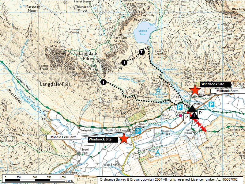
Great Langdale Map |
Legend |