W |
Ellerside |
| Status : | Red | ||
| Status Message : | |||
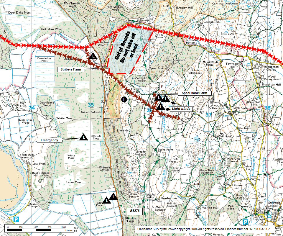
| IMPORTANT - Restrictions on use | This site closes for nesting peregrines around April / July period. All members please be aware that the landing areas at Frizz's Piece is closed for landings until further notice. We do not have permission to use the 'out of bounds' area of the hillside. There is to be no landing or taking off in this area. The permitted take off is to the immediate west of Speel Bank Farm. Thanks for your support |
||
| Last Updated : | 01/04/2024 at 09:06 by John Westall | ||
| Wind : | W | ||
| Nil Wind : | No | ||
| Grid Ref : | SD354805 | Height (AMSL) : | 490' / 149m |
| Site Code : | 17.063 | Top to Bottom : | 460' / 140m |
Location
S Lakes - S of Windermere
Details
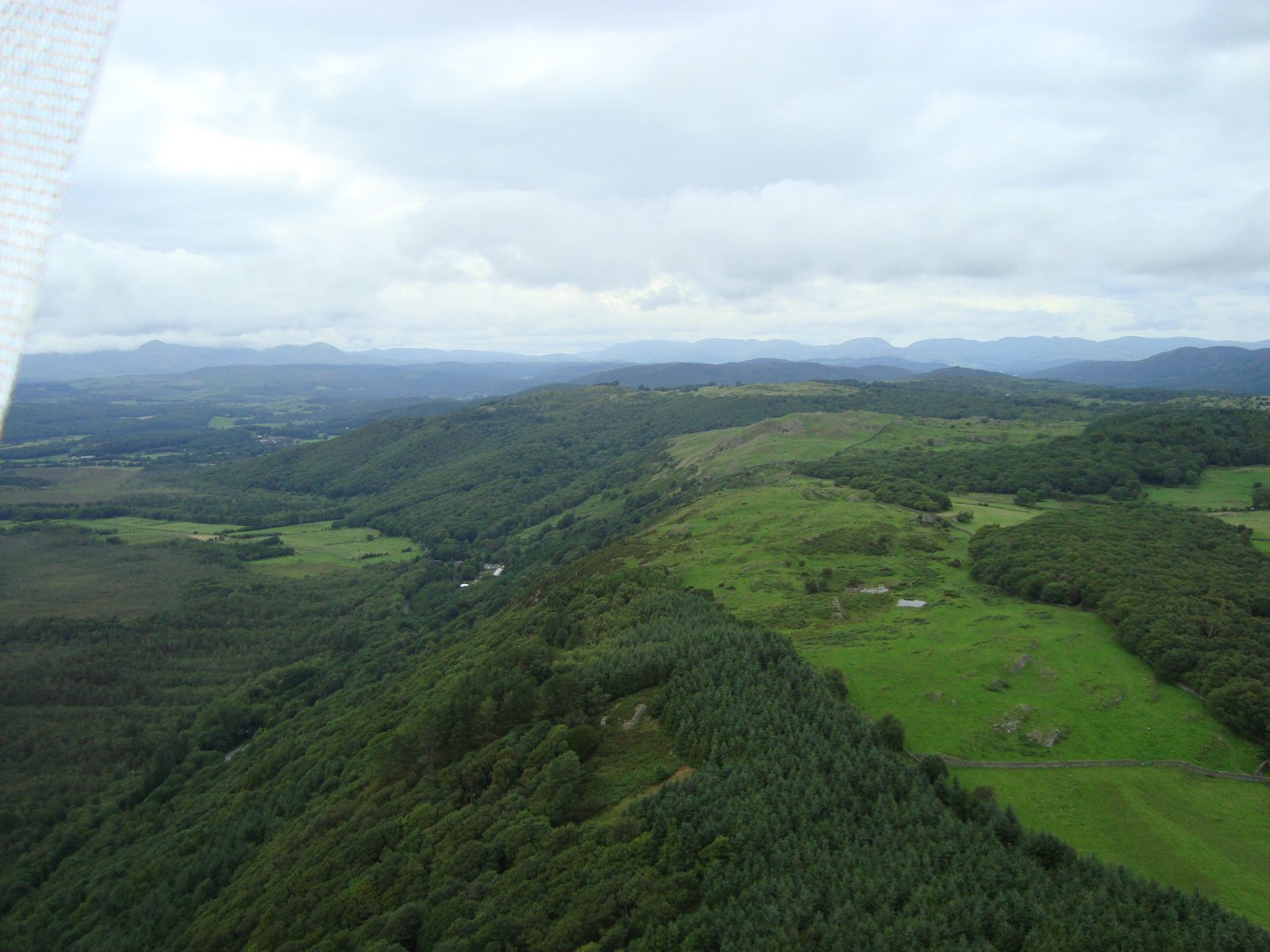
A superb site that deserves to be flown more often (very rarely flown by hang-gliders nowadays). A long, tree-covered ridge which gives a different character from other sites in the district. Tremendous views over the estuary and the western Lakes. Excellent bottom landing in fields in front of Stribers but beware of the power lines!
Site Officer
John Westall : 07884 037144
Postcode for Sat Nav Systems (read the Health Warning!)
LA11 7SP - This is the closest mail delivery point to the flying site and is positioned at:
Over Ridge. This is shown on both 1:25000 and 1:50000 OS maps. This is on the road to Speel Bank Farm and is 750m to the east. Keep following the road and you will get to Speel Bank
Getting There
For hang-gliders; approach from the back of the hill by taking the minor road to Speel Bank farm (ask permission.) For paragliders; either ask at Stribers for a parking spot and then walk to take off via the footpath running up the front of the hillside OR use the hang-glider approach via Speel Bank Farm.
Getting to takeoff
Park just beyond Speel Bank farm and inside the first field (do not block the track and ask at farm first.) The farmer will advise if it is OK to land in the same field. If bottom landing and you need to get back up hill then, follow road steeply up N end of hill, then follow the CCW, this takes you back to near Speel Bank OR access take off via the footpath running up the front of the hill (starting at SD 352808). Alternative parking is available at Stribers (ask first for permission).
Permission to use site
Stribers Farm (at base of hill on road junction)OR for the 'back of hill approach' ask at Speel Bank farm.
Additional Safety Notes
The site has few vices and is generally smooth with a generous lift band. Keep clear of the trees and beware of the power lines crossing the hill north of main take off and main pylons further north again. Private telephone at Stribers and Speel Bank. Public phones at Haverthwaite.
Paragliding
Only occasionally flown but with good reports. Be careful in strong winds as there is a danger of being blown backwards. Can be rough low over the trees if the wind is off to the south. Sea breeze can pull the wind off to the south. Landing fields to the south are some distance away. The ground is boggy and covered in trees out in front of the hill. Top landings on a paraglider are generally OK.
Hang Gliding
Can be rough low over the trees if the wind is off to the south.Top landings can be difficult on a hang-glider(do not go too far back). Avoid clumps of trees and/or possible rotor. Sea breeze can pull the wind off to the south.
XC potential
Good XC potential with flights possible to the Yorksire Dales, the Vale of York and beyond (allowing for Airspace Restrictions). Sea breeze is the main problem.
Videos
An all round video of the take off at Ellerside can be found on the Vimeo web site. The view starts by looking to the north.
Photos
Click on the photo for a full size image.
| Looking north from the south of take off. Stribers farm is at the bottom of the hill in the middle left of the photo. The B5278 cuts through the woods at the bottom of the hill. Photo by Roy Richards |
 |
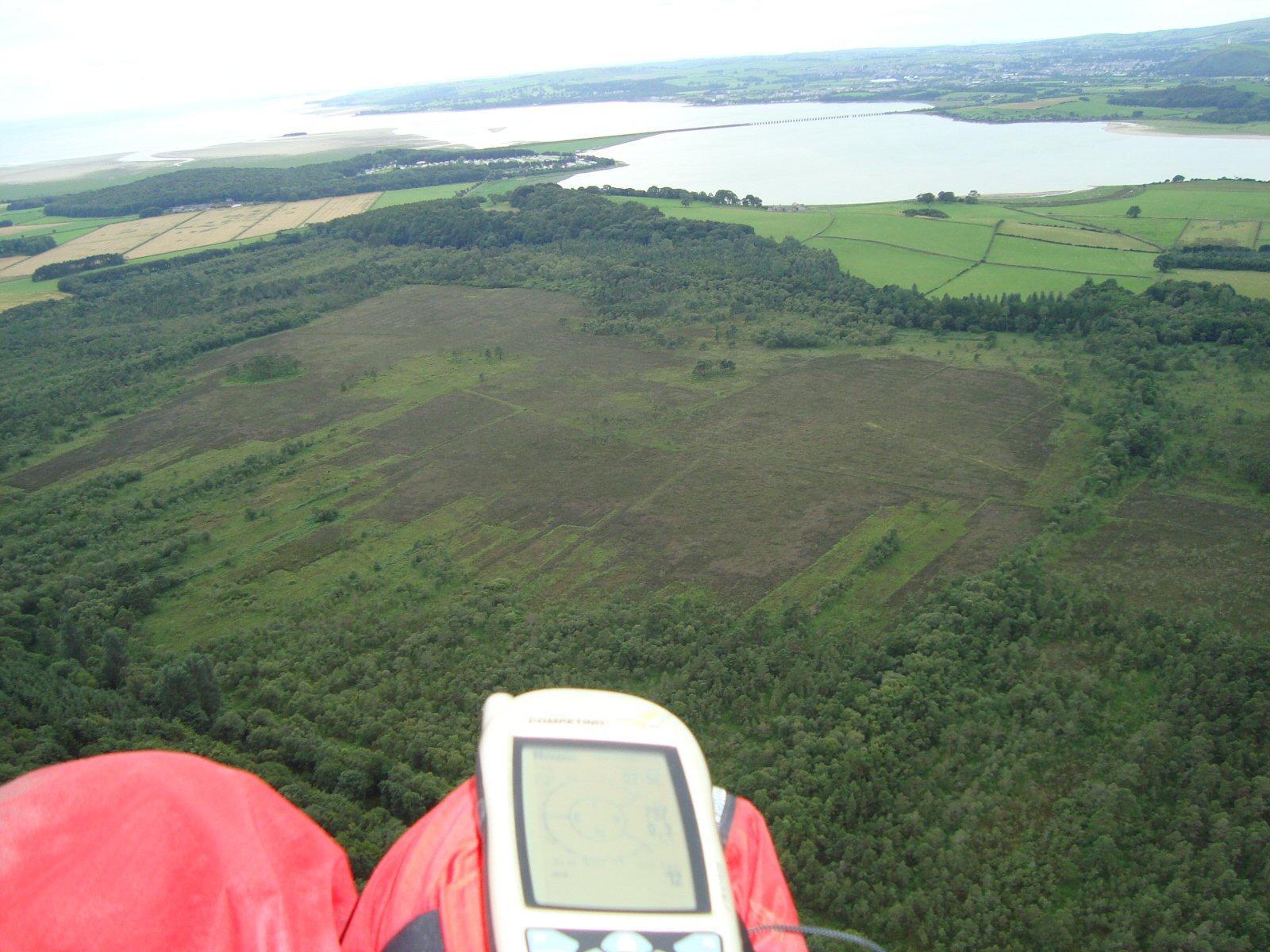
| Looking SW from the ridge. Ulverston is at the top right and the Levens railway viaduct crosses the estuary. Photo by Roy Richards |
 |
Local Information - Pubs/Food etc
Nearest pubs to the site - for post flying debriefing only! You may find details of other facilities here
No pub details are available for this site. Send your recommendations to the webmaster.
This page shows records for this site. Some of the older records are not very detailed. More recent records may have an igc file available You can right click and download this to your PC. You can then use IGC Flight replay to view the flight.
| Paragliding |
| Open Distance XC | |
| Distance : | 48.7km |
| Date : | 05/05/1996 |
| Pilot : | Mike Cavanagh |
| Hang Gliding |
| Open Distance XC | |
| Distance : | 48.7km |
| Date : | 05/05/1996 |
| Pilot : | Mike Cavanagh |
Data Resources
Follow the links to see the site in Google Earth and Google Street view. To access the former, you will need to have Google Earth installed on your PC. You can also upload your flights to GE - use GPS Dump (Links Page) to convert a variety of GPS file formats to a GE kml file.
| Link | Resource Type | Notes |
|---|---|---|
| Google Earth - Car Park | ||
| Google Earth - Sample Flight 1 | Mike Cavanagh's flight to Horton in Ribblesdale on 23 June 2008. 51.8km in 3.5 hours | |
| Google Earth - Take Off | Mike Cavanagh - 23 June 2008 |
Ellerside Map |
Legend |