ENE - SE |
Coniston Old Man |
| Status : | OK | ||
| IMPORTANT - Restrictions on use | Land only on the open fell. Cars cannot be left at the parking areas P1 or P2. All cars should be returned to the main car parking area by the fell gate. | ||
| Last Updated : | 22/05/2024 at 12:57 by John Westall | ||
| Wind : | ENE - SE | ||
| Nil Wind : | Yes | ||
| Grid Ref : | SD276974 | Height (AMSL) : | 1750' / 534m |
| Site Code : | Applied fo | Top to Bottom : | 850' / 259m |
Location
SW Lakes - Coniston
Details
This is a mega site that works well in light winds. The best direction is an easterly. The take-off above the quarry is a bit tricky but the bottom landing, near the fell gate car park, is huge.
Please be aware that flying low over the quarry should be avoided, there have been occasions where pilots have had serious collapses as a consequence of strong rocket thermals.
Site Officer
John Westall : 07884 037144
Postcode for Sat Nav Systems (read the Health Warning!)
LA21 8HQ - This is the closest mail delivery point to the flying site and is positioned at:
Sun Hotel in Coniston. On the rright as you go up the hill but before the steep part. Car parking is about a mile WSW of the Sun Hotel
Getting There
From the A593 turn right (if approaching from the north) just past the petrol station over the small bridge. Follow the minor tarred road (very steep for a short section) to the fell gate. Access is currently denied to drive the quarry track. Three options are available:1)Leave any vehicles at the fell gate parking area. At the gate head towards the fell for 100m following the track then walk up the fell side to the right side of the quarry. 2)Drive the track for 800m until access to the quarry track is barred by a drop down barrier. Unload equipment and then return the vehicle to the main fell gate parking area.3)As above, but if access has been agreed a 4WD can be driven to the quarry area. If the quarry is working then permission is generally given if asked.
Getting to takeoff
1)Head up the fell side to the right of the quarry from the track that runs north from the fell gate.2)Walk to the quarry via the track which has a short, steep section at the start or walk directly to the spoil heaps on the left of the quarry.
Permission to use site
This is an un-negotiated mountain site that has been flown for several years without any problems.
Additional Safety Notes
Beware of the sea breeze pulling the wind off to the south. The summit should be avoided in fresh winds. Do not attempt to top land except in very light winds; a rotor exists along the length of the summit ridge. Public telephone in Coniston village. Mountain Rescue post is at the base of the steep hill (turn right) on re-entering the village of Coniston.
Paragliding
Take-offs can be made almost anywhere but the summit area (2635� / 804m asl.) provides the cleanest launch points.
Hang Gliding
The only fact spoiling this site for HGs is the lack of permission for 4WD access via the quarry road. Exercise care on the less than ideal take-off areas that are rocky and be wary of the site in fresh winds.
XC potential
Thermals abound and, on a half decent day, a large area of high mountains, both to the north and south, can be explored. Downwind XC potential is limited but cross wind out and returns show great promise but are yet to be fully exploited.
Photos
Click on the photo for a full size image.
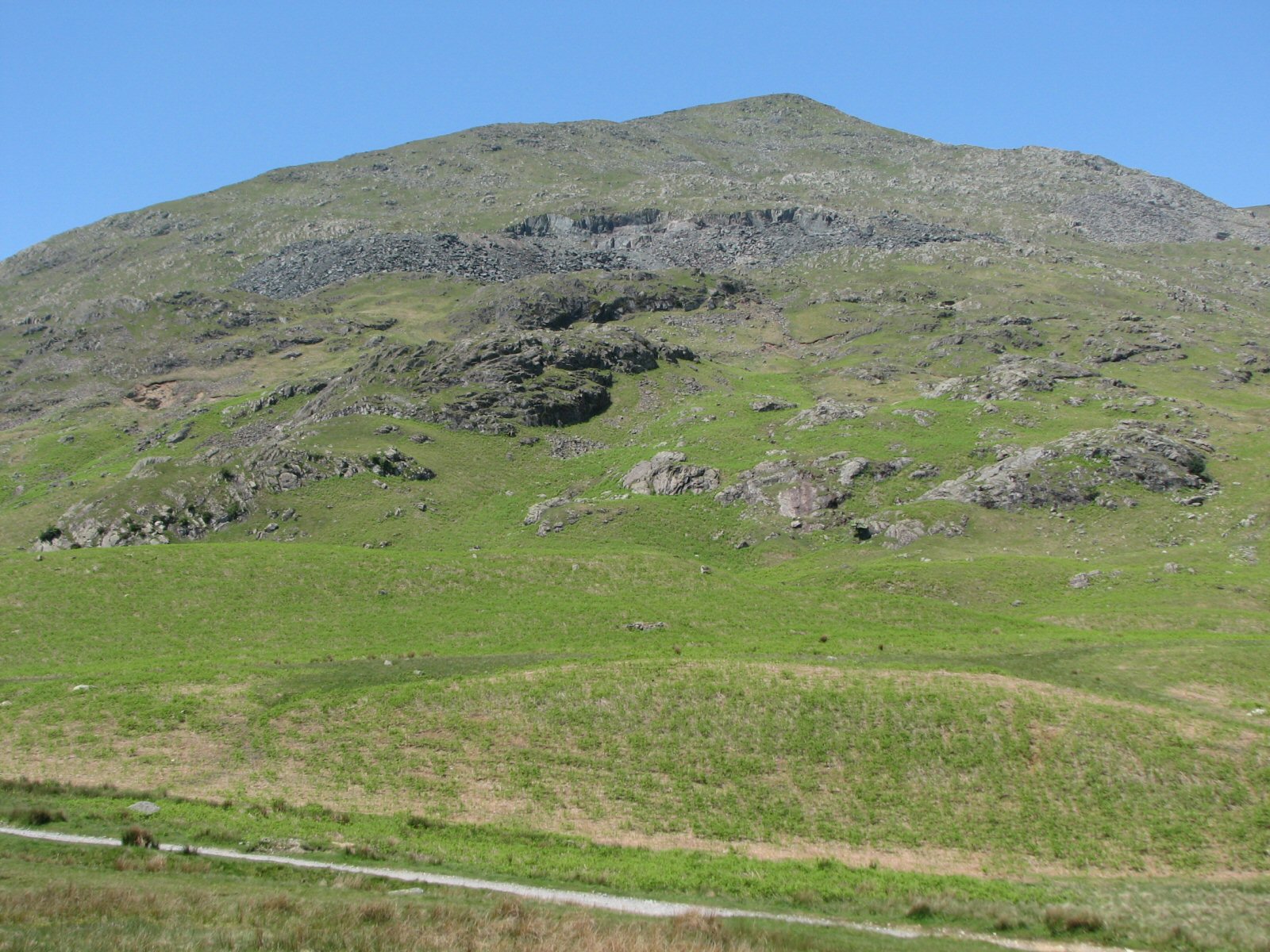
| Looking up at the east flank of Coniston from the car park. The Walna Scar road is in the foreground. You need to get above the quarry that can be seen about three quarters of the way up the hill. Above the quarry is a shelf where the best take off position can be reconnoitred. |
 |
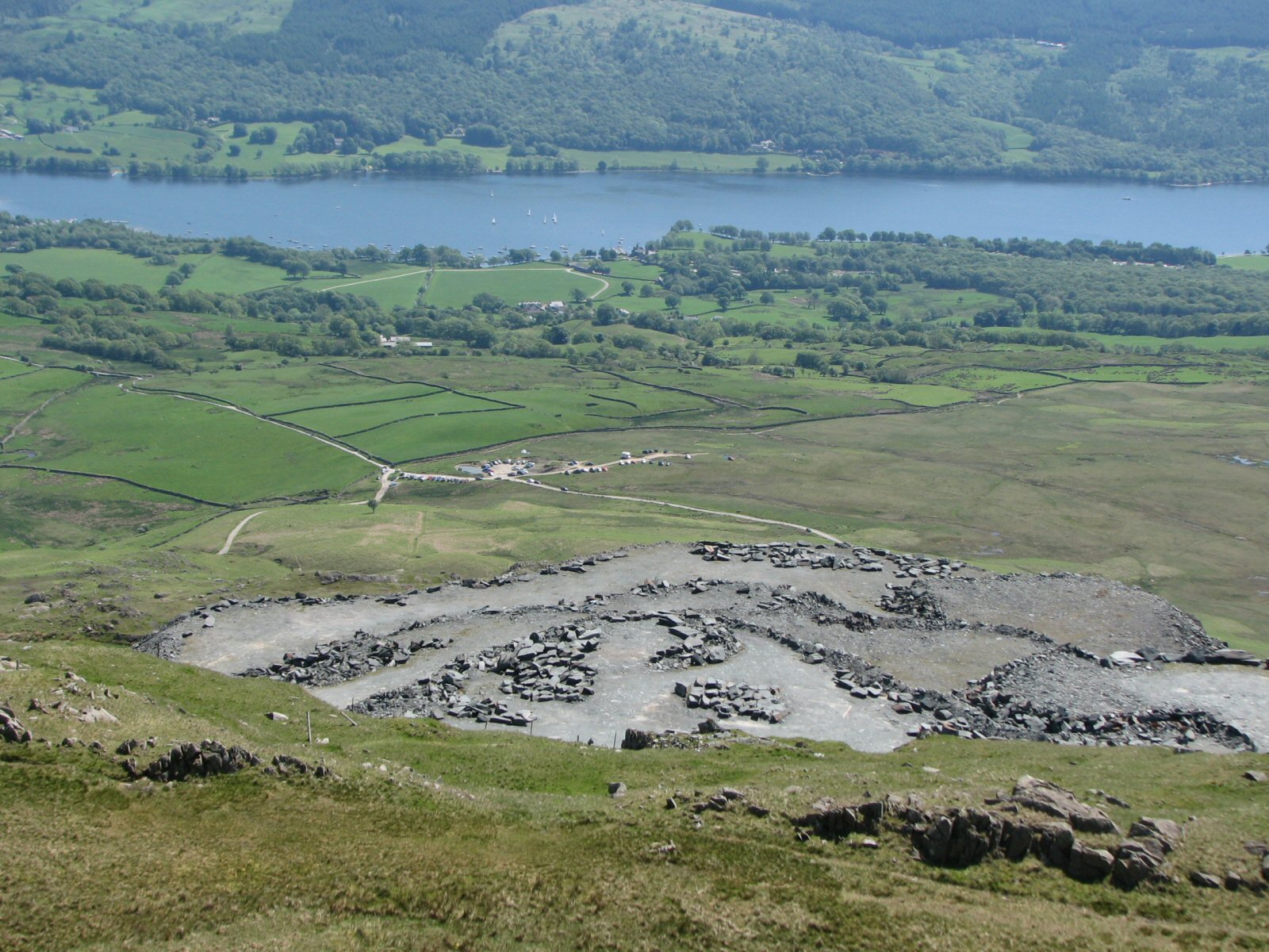
| Taken from above the Brim Fell ridge and looking across to the summit cairn of Coniston Old Man. The quarry shown in the next picture can be seen on the left flank of the hill. Coniston Water in the background. |
 |
| A good view of the Coniston massif, taken from the south. The Goats Water valley is in the centre of the photo with Dow Crag on the left and Coniston Old Man on the right. The car park is out of picture on the right. Photo by Matt Doncaster |
 |
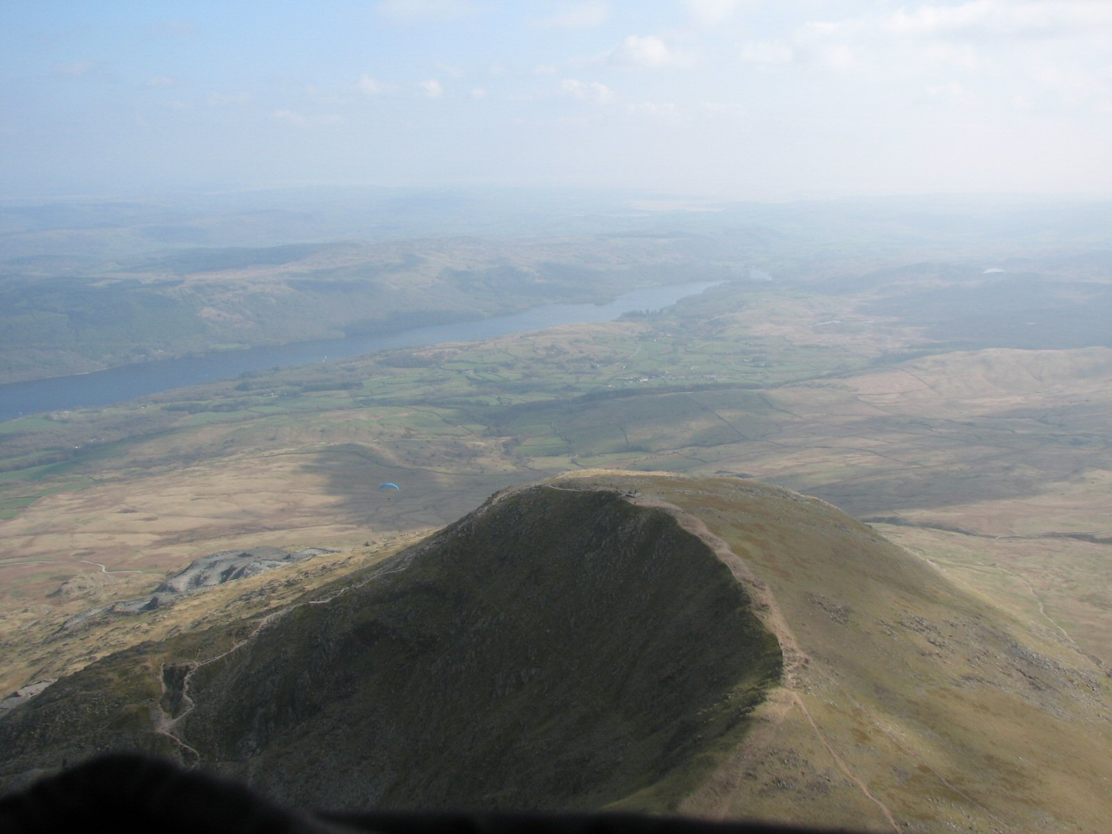
| Looking down on the Coniston car parking area at the eastern end of the Walna Scar road. It gets busy here most weekends. The area at the end of the track leading out to the right is generally used for landings as it's nice and level. There's loads of room. The undershoot - between the track and the Walna Scar road - can be boggy and a stream is near the road. The road down to Coniston is in the 10 o'clock position. |
 |
Local Information - Pubs/Food etc
Nearest pubs to the site - for post flying debriefing only! You may find details of other facilities here
No pub details are available for this site. Send your recommendations to the webmaster.
This page shows records for this site. Some of the older records are not very detailed. More recent records may have an igc file available You can right click and download this to your PC. You can then use IGC Flight replay to view the flight.
| Paragliding |
| FAI Triangle | |
| Distance : | 18.8km |
| Date : | 04/06/2013 |
| Pilot : | Chris Tyson |
| Notes : | |
| IGC File : | Right click to download |
| Open Distance XC | |
| Distance : | 38.1km |
| Date : | mid 2000 |
| Pilot : | Burkitt Rudd |
| Notes : | Flight to Cockermouth via the Langdales, Langstrath, Borrowdale with final glide over Winlatter pass. Wind moderate SE |
| Turnpoint Flight | |
| Distance : | 69.4km |
| Max Height : | 8199ft |
| Date : | 16/06/2023 |
| Pilot : | John Westall |
| Notes : | This record was achieved during the X-Lakes Challenge Hardcore Event. Although the flight started on the Coniston Old Man the race started in Grasmere where we made our way through the mountains to COM on foot. However I eventually landed near High Street after 5 hours non stop flying circumnavigation the Lakes, it was quite spectacular. I eventually finished my day at Dubbs Reservoir after 13 hours of hike and flying. |
| Hang Gliding |
| FAI Triangle | |
| Distance : | 18.8km |
| Date : | 04/06/2013 |
| Pilot : | Chris Tyson |
| Notes : | |
| IGC File : | Right click to download |
| Open Distance XC | |
| Distance : | 38.1km |
| Date : | mid 2000 |
| Pilot : | Burkitt Rudd |
| Notes : | Flight to Cockermouth via the Langdales, Langstrath, Borrowdale with final glide over Winlatter pass. Wind moderate SE |
| Turnpoint Flight | |
| Distance : | 69.4km |
| Max Height : | 8199ft |
| Date : | 16/06/2023 |
| Pilot : | John Westall |
| Notes : | This record was achieved during the X-Lakes Challenge Hardcore Event. Although the flight started on the Coniston Old Man the race started in Grasmere where we made our way through the mountains to COM on foot. However I eventually landed near High Street after 5 hours non stop flying circumnavigation the Lakes, it was quite spectacular. I eventually finished my day at Dubbs Reservoir after 13 hours of hike and flying. |
Data Resources
Follow the links to see the site in Google Earth and Google Street view. To access the former, you will need to have Google Earth installed on your PC. You can also upload your flights to GE - use GPS Dump (Links Page) to convert a variety of GPS file formats to a GE kml file.
| Link | Resource Type | Notes |
|---|---|---|
| Google Earth - Car Park | ||
| Google Earth - Landing | ||
| Google Earth - Take Off | ||
| Google Earth - Take Off 2 | ||
| Google Street View - Parking | The gate onto the fell at Coniston - it can get very busy here. Take off is above the quarry directly vertical from the top of the waymark sign - a long walk up! |
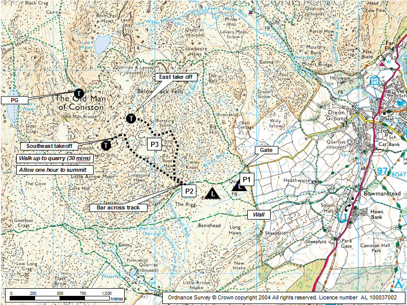
Coniston Old Man Map |
Legend |