NNW - NE |
Burnbank |
| Status : | OK | ||
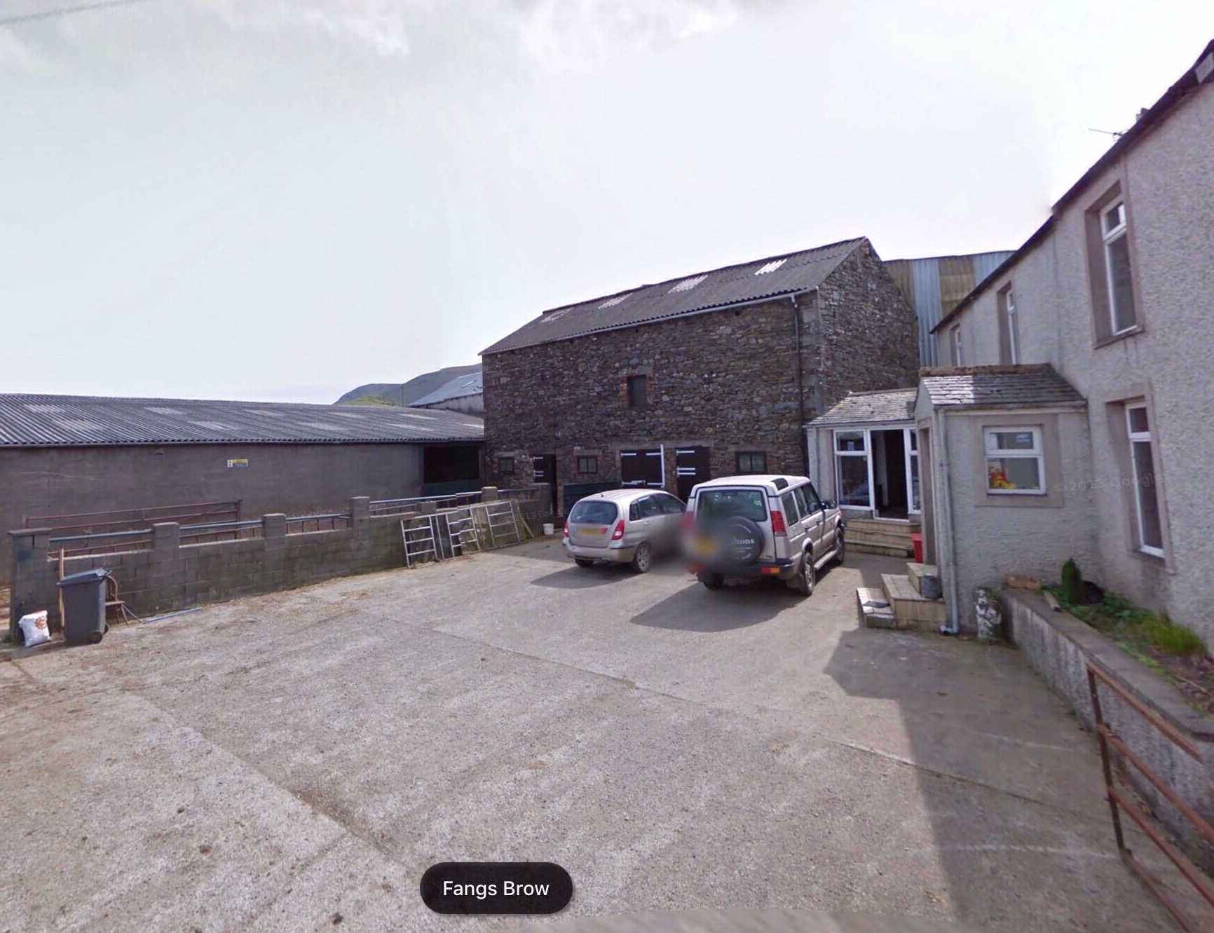
| IMPORTANT - Restrictions on use | - BEFORE you fly, a FEE of £1 PER PILOT is to to be paid at the farm at the top of Fangs Brow. This link (or Photo 2) shows the farmyard, leave money on the step the LandRover is pointing at. - Close all gates unless tied or propped open. - NOTE: There are no longer any landing field restrictions between the fell and the parking area - but avoid disturbing livestock if possible. |
||
| Last Updated : | 24/03/2023 at 16:46 by Rick Livingstone | ||
| Wind : | NNW - NE | ||
| Nil Wind : | No | ||
| Grid Ref : | NY112213 | Height (AMSL) : | 1470' / 440m |
| Site Code : | 17.058 | Top to Bottom : | 624' / 190m |
Location
NW Lakes - W of Loweswater
Details
Popular with local pilots and, on the right day, worth a longish drive.
The flying here can be very good with spectacular scenery and a great place to escape the crowds.
It is one of the few northerly sites available but note that in summer it can seabreeze early from the west (safety not affected).
Burnbank offers various XC opportunities from short first steps to full on epic mountain flights for the experienced.
Site Officer
Rick Livingstone : 07761187016
Postcode for Sat Nav Systems (read the Health Warning!)
CA13 0SU - This is the closest mail delivery point to the flying site and is positioned at:
Grange Country House Hotel. The postcode covers a large area. The hotel is one mile north of the flying site and lies to the east of the parking area. G
Getting There
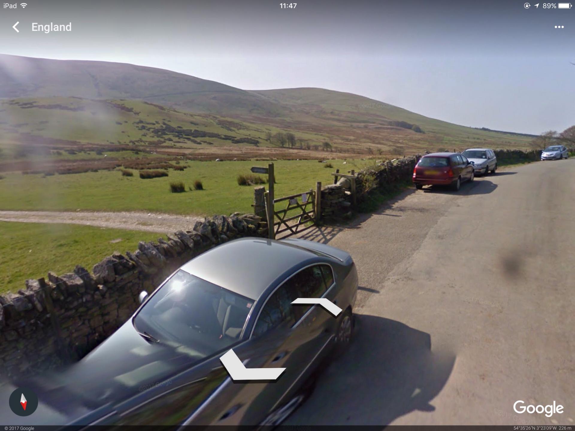
The best approach is from the A5086 via Mockerkin. Alternatively, the site can be approached via the scenic route from Keswick - this follows the Whinlatter Pass and the Lorton Vale to Loweswater. Parking is on the side of the road outside the entrance gate.
Getting to takeoff
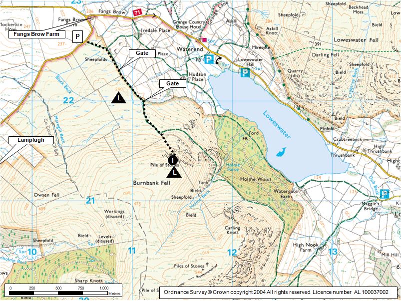
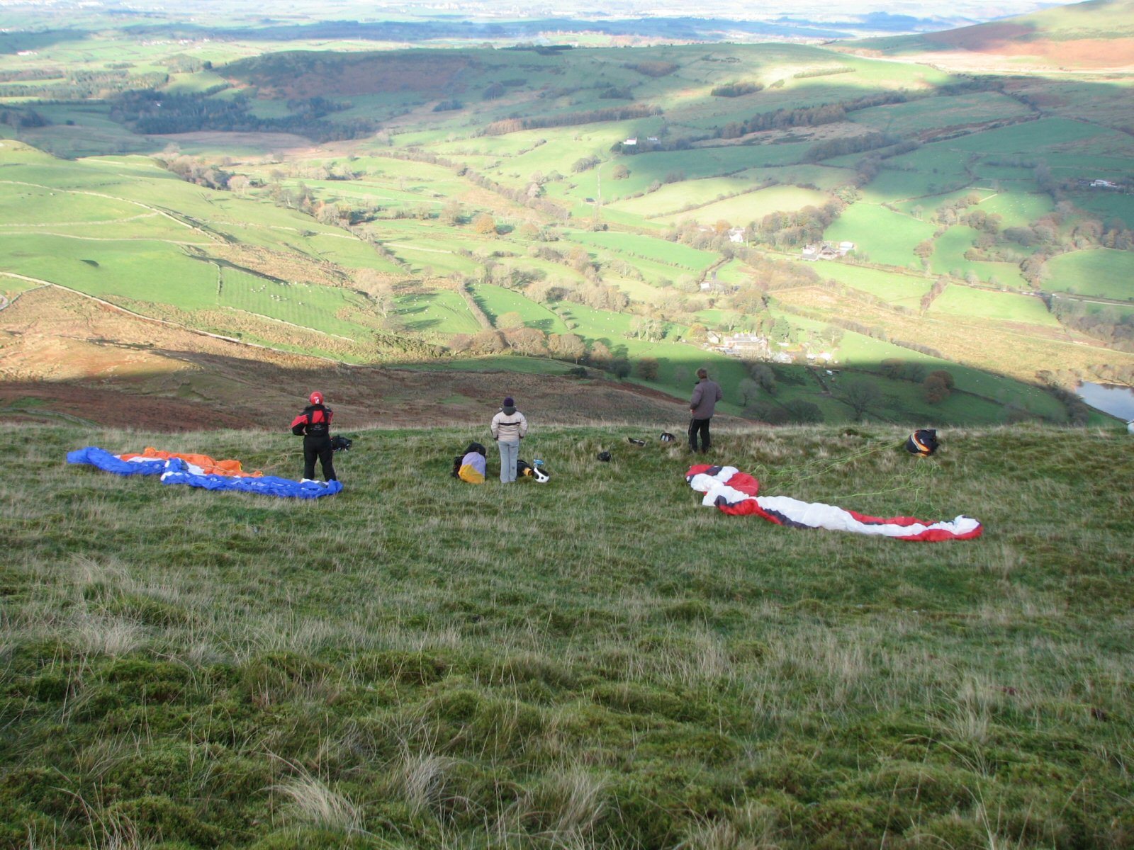
See Photo 1. From the entrance gate follow the unsurfaced road. After the next two gates strike off straight up the fell. Initially the path is indistinct but becomes obvious where it becomes steeper, this final section of the walk up is a short but steep haul. Once at the top there is a good choice of flat grassy take offs.
Hang glider pilots may seek permission to drive to the foot of the hill (needs
4x4), unload and then drive back to the road to park.
Permission to use site
The Clark family, Fangs Brow Farm.
Hazards
Suitable for novice CPs as long as they don't stray from the site and they respect both windy days and strongly thermic days.
Beware of turbulence in fresh winds. The site can become increasingly turbulent the more easterly the wind and the stronger the wind.
If going XC: Before going deep into, or high over, the big mountains make sure you know what you're doing & where you are going. Otherwise fly in radio contact with a competent guide and ensure you don't lose height close downwind of summits or behind spurs thereby dropping into rotor and severe turbulence. If it's a windy day (over 10mph?) think twice before making committing moves! NOVICES BEWARE!!!
Take Off
One of the few northerly sites available this is a favourite with local pilots and worth the drive on the right day.
There are various grassy take off areas allowing for differing wing directions.
Beware of turbulence in fresh winds, especially so if there is an increasing easterly component to the wind.
In summer the site can seabreeze early from the west becoming un-soarable, but without particularly affecting safety.
Landing Areas
This site has excellent top and bottom landings, plus nearby XC landing areas - see Photo 1.
There is a very big flat grassy area extending behind take off and the site is generally 'top landing friendly'.
- NOTE: There are no longer any landing field restrictions between the fell and the parking area - but avoid disturbing livestock if possible.
Flying
Given the right wind conditions; the flying here can be very good throughout the year, spectacular scenery and a great place to escape the crowds.
XC potential
XC POTENTIAL
Burnbank offers various excellent XC opportunities from first short steps to full on epic mountain flights for the experienced.
A flight 1km SE to Carling Knott and back is easy. Flights towards the Kirkstile Pub and then onto Melbreak give plenty of landing options and we have permission to land in the fields you will fly over.
For experienced XC pilots: Due south the terrain is remote and care should be exercised, the potential for a long walk out is quite high! The ridge from Red Pike to Herdus works well and a flight over High Stile and the Buttermere fells or a crossing over Enerdale enables further options.
Photos
Click on the photo for a full size image.
| Photo 2: Shows the yard at Fangs Brow Farm; leave money on the step the Land Rover is pointing at. |
 |
| Photo 3: View of parking area and fell gate. |
 |
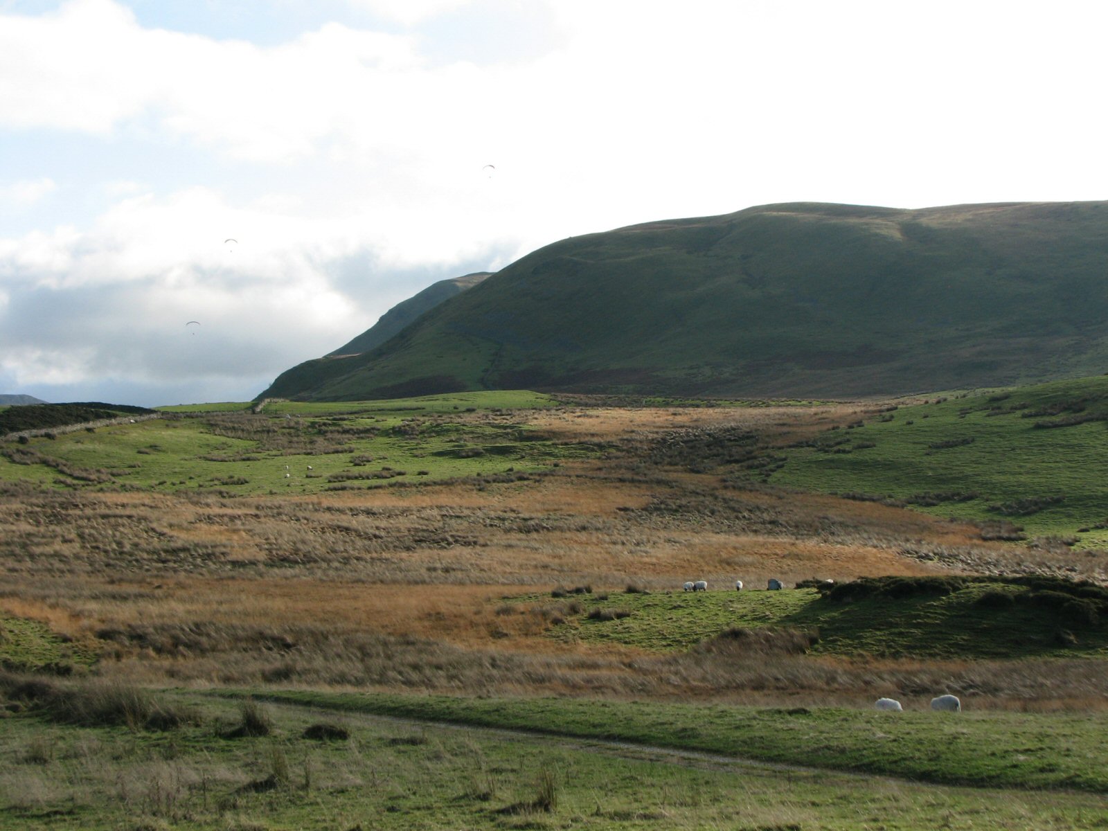
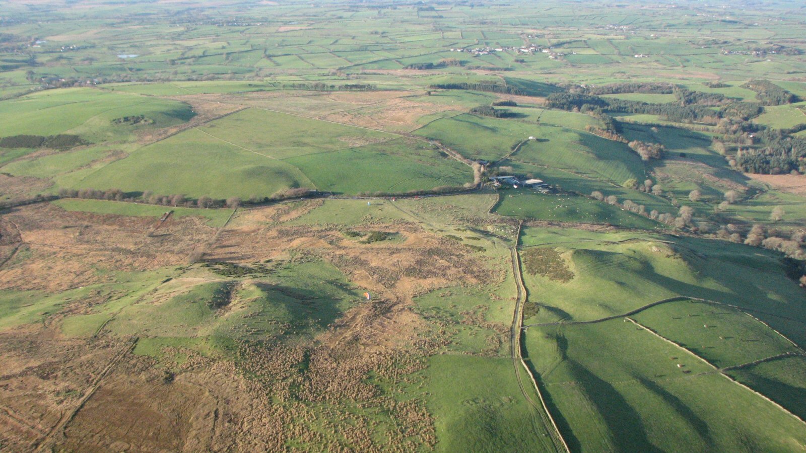
| Photo 4: A general view of Burnbank Fell. The pimples at the top of the steep slope are paragliders at takeoff. The track to takeoff goes to the left immediately in front of the camera and then curves round to the right and follows the wall up the fell |
 |
| Photo 5: Take off is where the path starts to level off near the top of the hill. There is a marked level shelf as seen in the photo - watch out for no wind in the hollow |
 |
| Photo 6: In the centre of the picture is the parking area by the road with the path leading up onto the fellside coming diagonally right towards the camera. A good landing area is above the first gate on the fell (i.e. the rectangular grassy area to the left of the wall in the middle right at the foot of the photo.) but now it's OK to land anywhere between the fell and the parking |
 |
Local Information - Pubs/Food etc
Nearest pubs to the site - for post flying debriefing only! You may find details of other facilities here
| The Kirkstile Inn | |
| Grid Reference : | NY141209 |
| Distance from Site : | 3.0 miles |
| Notes : | Good range of local real ales and excellent food. |
| Click here to go to the web site | |
| Click here to see the place in Google Street View |
This page shows records for this site. Some of the older records are not very detailed. More recent records may have an igc file available You can right click and download this to your PC. You can then use IGC Flight replay to view the flight.
| Paragliding |
| FAI Triangle | |
| Distance : | 38.1km |
| Date : | 06/04/2019 |
| Pilot : | Philip Kew |
| Notes : | Phil Kew says "A Tricky triangle with strong winds, turn points were Honister pass, Bleaberry fell and a fantastic return leg over Grasmoor, finished off with a pint of Loweswater Gold in the Kirkstile Inn with the lads." |
| IGC File : | Right click to download |
| Open Distance XC | |
| Distance : | 39.6km |
| Date : | 28/04/1996 |
| Pilot : | Ian Hall/Pete Brown |
| Hang Gliding |
| FAI Triangle | |
| Distance : | 38.1km |
| Date : | 06/04/2019 |
| Pilot : | Philip Kew |
| Notes : | Phil Kew says "A Tricky triangle with strong winds, turn points were Honister pass, Bleaberry fell and a fantastic return leg over Grasmoor, finished off with a pint of Loweswater Gold in the Kirkstile Inn with the lads." |
| IGC File : | Right click to download |
| Open Distance XC | |
| Distance : | 39.6km |
| Date : | 28/04/1996 |
| Pilot : | Ian Hall/Pete Brown |
Data Resources
Follow the links to see the site in Google Earth and Google Street view. To access the former, you will need to have Google Earth installed on your PC. You can also upload your flights to GE - use GPS Dump (Links Page) to convert a variety of GPS file formats to a GE kml file.
| Link | Resource Type | Notes |
|---|---|---|
| Google Earth - Car Park | ||
| Google Street View - Parking | Burnbank on a nice day, parking is on the left. |
Burnbank Map |
Legend |