S - SSE |
Blease Fell |
| Status : | OK | ||
| IMPORTANT - Restrictions on use | LANDING FIELD - NO LANDING FIELDS are available below the fell wall APART FROM the designated landing field adjacent to the A66 and north east of the car park (this field was formerly known as the football field but now without goalposts). Also see map and photos for location. - Note that the field is CLOSED IN APRIL if there is stock in it (but it is ok to land with stock in it in other months). - DO NOT MIX IT UP with the school games field in the centre of the village. - DO NOT land in any other fields. - Visiting pilots have caused problems here by ignoring the site guide. Further infringements may result in site closure to non CSC pilots. PARKING NEXT TO LANDING FIELD The car park is now PAY & DISPLAY (£3 for all day, no overnighting) |
||
| Last Updated : | 01/04/2024 at 00:28 by Rick Livingstone | ||
| Last Reviewed : | 01/04/2022 by | ||
| Wind : | S - SSE | ||
| Nil Wind : | Yes | ||
| Grid Ref : | NY306261 | Height (AMSL) : | 1540' / 470m |
| Site Code : | 17.023 | Top to Bottom : | 720' / 220m |
Location
N Lakes - Blencathra
Details
An excellent and very demanding site. Blease Fell is a large grass covered mountain that rises up from the Glenderaterra Beck on to the west and Threlkeld to the south. The site is notorious for generating massive lift and once airborne there is the possibility of soaring the whole Blencathra range and jumping across the gap to Jenkin Hill and then onto Skiddaw. The lift often extends well in front of the hill and it is not uncommon to have to fly out past the A66(T) before finding sink.
Hangliders: A tough carry. Landing is in the recreation field (the old football field) adjacent to the cricket pitch south of the A66(T).
Please refer to the notes on 'Flying' tab for more details
Site Officer
Rick Livingstone : 07761187016
Postcode for Sat Nav Systems (read the Health Warning!)
CA12 4SG - This is the closest mail delivery point to the flying site and is positioned at:
Blencathra Centre. Make sure that you take the right fork when within 200 metres of the post code location
Getting There
Approach by exiting the A66(T) at Threlkeld and proceed up through the village taking the steep road north towards the Blencathra Centre. Park in the car park at the end of the road just above and beyond the centre. The parking area can become very busy.
If car sharing and leaving a car at the bottom in the car park next to the Landing Field; note it is PAY & DISPLAY.
Getting to takeoff
It is a steep carry up the path from the car park until you clear the bracken line. The slope then eases and then leads to large areas to take off from.
Permission to use site
Arrange by Northern Sites Officer
Hazards
Extreme care must be taken on breezy days as being blown back is not an option!
Always keep a check on your ground speed and push forward to avoid being blown back if the wind picks up (take particular care when flying along the back ridge) This has caught out a few pilots
Blencathra is a long mountain ridge and there are no escape routes other than to push forward
If the wind turns more markedly East or West take great care in the gulleys along the Blencathra massif and avoid these in windy conditions
In certain conditions. a sea breeze can come from the Solway Firth (ie "over the back") and therefore flow down the hill. This is not what a pilot may expect, (as in this area the sea breeze usually arrives from a more westerly direction - along Bassenthwaite lake) Whilst this may be unusual, it renders the site dangerous. Keep vigilant.
Power lines in field adjacent to Landing Field (2 sets: N-S & E-W)
There are also powe rlines between take off and the designated landing field (it is a village!) - but these should not present a hazard as you won't be landing here!
Speedwings are unlikely to be able to make the designated landing field - having to land on the fellside means this is not a great choice of site. Please do not land in other fields, as this may result in us losing one of the CSC's best flying sites!!
Take Off
On a good day, you can take off on the large broad grassy shoulder.(Be aware that this is only over half way up the hill so keep an eye on the wind strength after take off as you gain altitude)
In light winds you may need to walk higher.
Landing Areas
Do not attempt to land on the small track leading north west out of the car park ( the "old landing area"). This is very demanding and it has been the source of many accidents. It used to be that landing was possible here but the greater performance of modern paragliders makes this much more of a challenge. Also the trees have grown considerably and can cause considerable turbulence. (Do not assume that if other pilots are landing in this area it is safe to do so Use your own judgement and experience)
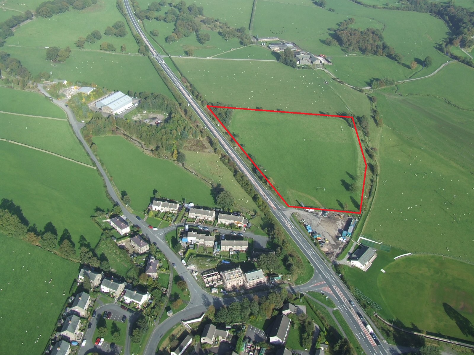
Please do not land below the fell wall unless you can land at the Threlkeld landing field adjacent to the A66 (the former football field) .
It is shown as the landing field on the site map. Also refer to the photos section for more detail.
Check you know which is the Landing Field before you take off (you may hear people refer to it as the Football Field - but the goalposts are long gone. Do not confuse it with the school playing field in the middle of the village which does have goal posts, but would be a VERY dangerous choice of landing).
The landing field is closed in April when there are lambs and sheep here.
NOTE THAT IN OTHER MONTHS IT IS OK TO LAND HERE EVEN WITH STOCK IN THE FIELD.
There are two sets of power lines in the adjacent field immediately to the South of the landing field. These run from the bottom of the cricket pitch to the corner of the landing field
Do not land in any of the fields around the designated landing field (unless one has been negotiated for the day by special arrangement and has a windsock in it - a very exceptional occurrence organised by the sites officer or a club official)
If the designated landing field is unavailable (rare), slope land above the bracken as there is no other agreed landing below the fell wall.
"Top" landing is excellent on the large, broad, grassy shoulder.
Flying
Probably the most demanding site in the North Lakes area. The flying and the lift generated can be very intimidating. It has been known for pilots to take off and spend the next hour in big ears before getting below take off.
Pilots must be very comfortable in strong thermals and be confident at landing in the designated field.
If flying here for the first time, please get a site briefing from an experienced local or contact the site officer, Chris Little 07307864418
Always keep a check on the wind speed and your ground speed when flying here There are no escape routes if being blown backwards Push forwards early if in doubt
XC potential
Excellent potential both downwind and, in the right conditions, for achieving large 'triangle' flights. Take great care to keep well forward of windy gap if traversing west towards Skiddaw. Keep a check on your ground speed and push forward to avoid being blown back if the wind picks up (take particular care with this when flying along the back ridge)
Photos
Click on the photo for a full size image.
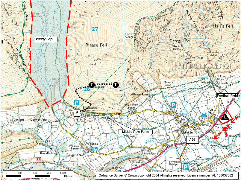
| An aerial view of Blease Fell looking NW. Take of is the area above the bracken line in the centre of the picture. Photo reproduced with the permission of the copyright owner, Andrew McMahon. More pictures can be found on his web site. |
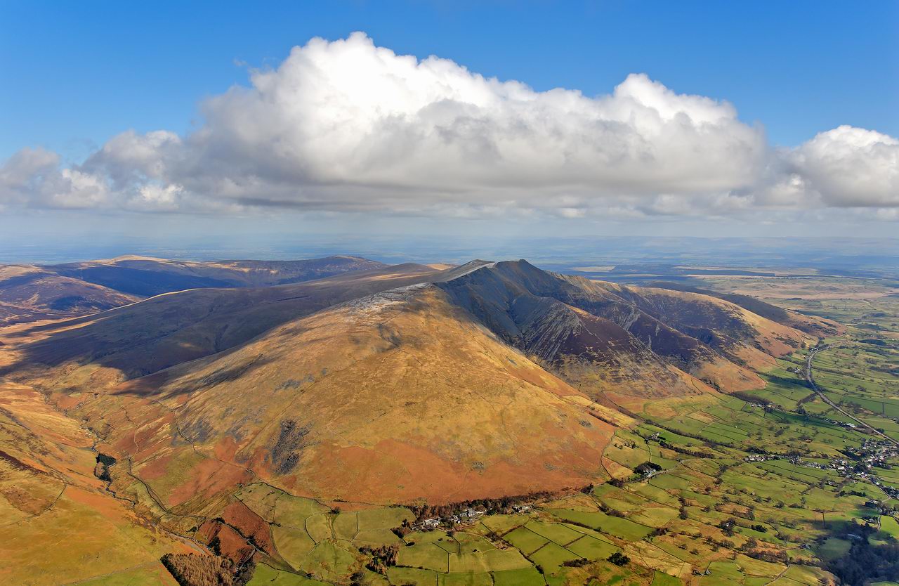 |
| A general view of Blencathra from SW. Blease Fell is the grassy western flank of the mountain, dominating the centre left of the photo. |
 |
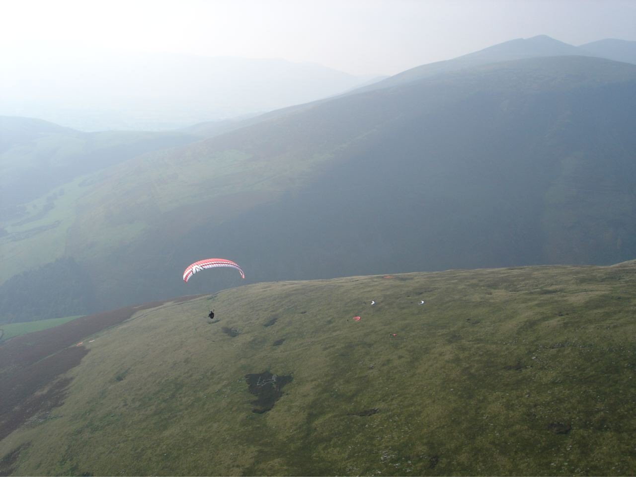
| Looking down on the take off area. On the left of the picture, 2 wings have landed on the side of the walk up track which continues down through the bracken. To the left of the flying wing, the walk up track continues up to the ruined building in the foreground. This is on a "shelf" which marks the general take off area. Photo by John Hamlett |
 |
| The restricted area near the car park on Blease Fell. Do not attempt to land here! Modern paraglider performance makes this a non viable landing area |
 |
| A good view of the football field on the south side of the A66 and SE of Threkeld. Note the goalposts have since been removed, Photo by Dave Horne |
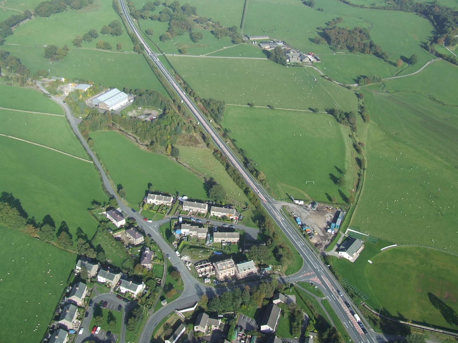 |
| The football field (for landing) is clearly marked in this photo. Avoid landing in any other fields. |
 |
Local Information - Pubs/Food etc
Nearest pubs to the site - for post flying debriefing only! You may find details of other facilities here
| Horse and Farrier, Threkeld | |
| Grid Reference : | NY322254 |
| Distance from Site : | 1.3 miles |
| Notes : | A Jennings pub in Threkeld immediately below Blease Fell. The Treasurer reports that the food is excellent! (Oct 2010). |
| Click here to go to the web site | |
| Click here to see the place in Google Street View |
This page shows records for this site. Some of the older records are not very detailed. More recent records may have an igc file available You can right click and download this to your PC. You can then use IGC Flight replay to view the flight.
| Paragliding |
| Declared Out and Return | |
| Distance : | 38.2km |
| Date : | 03/06/2012 |
| Pilot : | Multiple Pilots |
| Notes : | A number of pilots completed this as an LCC task (this became briefly a National Declared Out and Return record). |
| IGC File : | Right click to download |
| FAI Triangle | |
| Distance : | 49.9km |
| Date : | 27/04/2011 |
| Pilot : | Phil Wallbank |
| Notes : | Record triangles also set this day on CatBells (Rod Welford -49.6km) and at Wrynose (Mike Cavanagh - 50.9km) |
| IGC File : | Right click to download |
| Turnpoint Flight | |
| Distance : | 108.9km |
| Date : | 11/07/2009 |
| Pilot : | Mike Cavanagh |
| Notes : | The flight that broke the 100km straight line record from a Cumbrian flying site. The flight took 3 hrs 20 mins from Blease to Crawford in the Clyde valley. |
| IGC File : | Right click to download |
| Hang Gliding |
| Declared Out and Return | |
| Distance : | 38.2km |
| Date : | 03/06/2012 |
| Pilot : | Multiple Pilots |
| Notes : | A number of pilots completed this as an LCC task (this became briefly a National Declared Out and Return record). |
| IGC File : | Right click to download |
| FAI Triangle | |
| Distance : | 49.9km |
| Date : | 27/04/2011 |
| Pilot : | Phil Wallbank |
| Notes : | Record triangles also set this day on CatBells (Rod Welford -49.6km) and at Wrynose (Mike Cavanagh - 50.9km) |
| IGC File : | Right click to download |
| Turnpoint Flight | |
| Distance : | 108.9km |
| Date : | 11/07/2009 |
| Pilot : | Mike Cavanagh |
| Notes : | The flight that broke the 100km straight line record from a Cumbrian flying site. The flight took 3 hrs 20 mins from Blease to Crawford in the Clyde valley. |
| IGC File : | Right click to download |
Data Resources
Follow the links to see the site in Google Earth and Google Street view. To access the former, you will need to have Google Earth installed on your PC. You can also upload your flights to GE - use GPS Dump (Links Page) to convert a variety of GPS file formats to a GE kml file.
| Link | Resource Type | Notes |
|---|---|---|
| Google Earth - Car Park | ||
| Google Street View - Parking | Google Street View doesn't go any further but you're almost there. Continue up the track on the right over a cattle grid. Parking can get busy. |
Blease Fell Map |
Legend |