|
Article updates and notes. Article author: Geoff Moss. A Pilot rated club member who has an above average interest in techie things. This article was written in 2016 just before Garmin bought DeLorme. Update May 2018 - The Garmin inReach mini Here's a written in-depth review of the inReach mini by DC Rainmaker and here's a good hands-on video review from HikingGuy.com which is part of this companion article. My own inReach mini review is more paragliding focused but doesn't add much that's not covered in the two great reviews above.
Contents Personal Locator Beacons Satellite emergency notification devices Links to... This article looks at Personal Locator Beacons and Satellite Emergency Notification Devices to see what they offer to paraglider and hang glider pilots. The differences between a 'PLB' and a 'SEND' are explained and typical SOS, messaging and tracking features are explored.
It's not intended to review specific models. However the popular SPOT and DeLorme inReach models are often referenced as they illustrate the kind of things to consider. Carrying any of these devices when you fly will improve your safety and some offer good communication options too. Hopefully there's enough information here to help you make an informed choice if you're thinking about buying one.
Personal Locator Beacons (PLB) and Satellite Emergency Notification Devices (SEND). These are the two types of satellite device of most interest to paraglider and hang glider pilots. Both are designed to work in remote areas away from any cell phone signal.
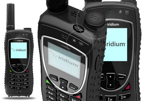
It's probably worth mentioning another option, the satellite phone. Of course these offer voice calls away from cell phone coverage. They are larger than a PLB or SEND. They are also much more expensive, both for the hardware and the service subscription. The ruggedized Iridium Extreme 9575 (about £1000) offers voice, SMS texts, GPS tracking and an SOS function. Voice focussed, it could be a useful tool for an expedition group but it's probably not appropriate for the average free flier.
All satellite devices need a clear view of the sky and their effectiveness can be affected by foliage, a nearby mountain, bad weather, solar flares, atmospheric conditions and electrical interference. There may be times and places where no satellite device will work and yet you may still have a mobile phone signal. So if you want to be as safe as possible, take your cell phone too.
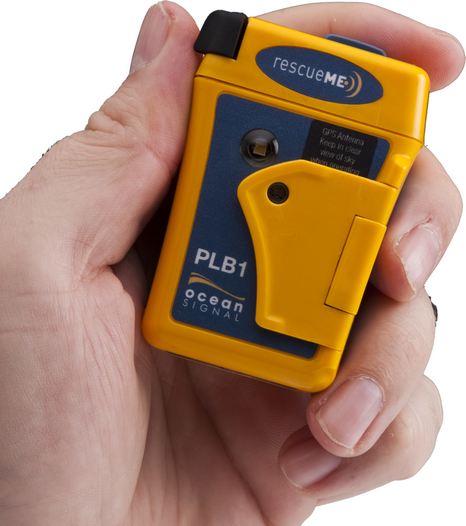
A personal locator beacon is a small, hand held, battery powered device that's perfect for individuals. It's a good choice for climbers, mountain bikers and free fliers etc. The SOS transmission (which includes GPS location) is started manually. If you haven't heard of PLBs that might be because they only became legal to use on land in the UK in 2012.
Some jargon busting....a PLB is one of a group of similar devices known as EPIRBs (Emergency Position Indicating Radio Beacons). EPIRBs are basically just larger. They are used on boats and planes. On planes they are known as ELBs or ELTs (emergency locator beacon/transmitter). On boats or planes most are triggered automatically, by immersion in water or the G-force of a plane crash.
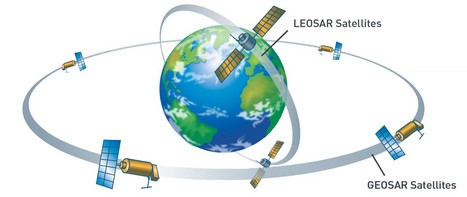
Taken from the Cospas-Sarsat 'Our Mission' web page... "Mission - The International Cospas-Sarsat Programme provides accurate, timely, and reliable distress alert and location data to help search and rescue authorities assist persons in distress." This organisation is government funded by many collaborating countries and was established in 1979. The Cospas-Sarsat organisation includes a dedicated satellite system and a large number of ground based facilities distributed all over the globe. This system was set up specifically for search and rescue duties. It has a good track record and has proven its reliability over 30 years of use. The satellite network uses a mix of geostationary (GEOSAR) and moving satellites (LEOSAR). These are linked to permanently staffed ground receiving stations which quickly alert the relevant national rescue authorities when an SOS is received. The Cospas-Sarsat website explains the detail of this process. The system has been around for a long time and works well.
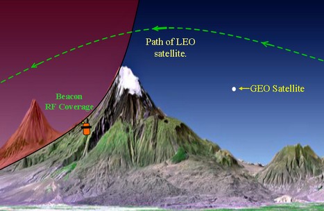
GEOSAR satellites can relay SOS information, including GPS location, to ground stations almost immediately. However these stationary GEOSAR satellites cannot locate a PLB if the PLB is not transmitting GPS location data. Fortunately the movement of the LEOSAR satellites does enable them to locate a PLB, even if it's not transmitting a GPS fix.
There are five operational LEOSAR (low earth orbit search and rescue) satellites about 850km up. They are travelling extremely fast and orbit the earth in roughly 100 mins. They provide complete global coverage but because they are moving their coverage of any one spot is not continuous. They all have orbits which pass through both poles. So the poles are covered most frequently and the equatorial regions least often. On the ground this means that there will be times when there may not be any LEOSAR satellite in the sky and it might be a short time before one appears to pick up an SOS transmission. A wait of under an hour is typical in the mid-latitudes. These moving LEOSAR satellites allow a PLBs location to be determined without receiving GPS location info. So, how's it done? The pitch of a siren on a speeding police car will drop as it passes you in the street. This change in the pitch from higher to lower is caused by the cars motion and the phenomenon is known as the Doppler effect. The animations below show how frequency (pitch) is affected by movement. Where the lines are closer together the frequency is higher, where they are more spread out the frequency is lower.
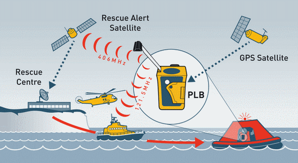
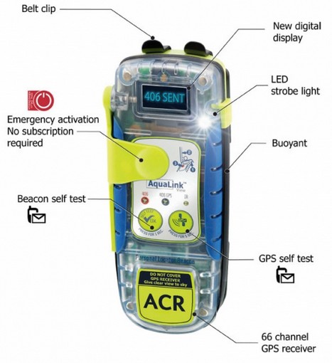
So to recap, the Cospas-Sarsat satellite constellation can locate a PLB in two separate ways... When a LEOSAR satellite picks up an SOS signal from a PLB it will store the data until it moves over a suitable ground station at which point the data is passed on. Here in the UK we're covered by both the GEOSAR and LEOSAR satellites. The system has been refined over the years and is continuing to be improved. There will soon be a third additional MEOSAR satellite constellation that will provide almost instantaneous detection and location of PLBs. It's anticipated that this will reach full operational capability in 2018. When finished (around 2020) there are likely to be over 50 satellites in orbit offering 100% global coverage. Several satellites should be in view from any point on the planet, offering multiple routes for SOS signals to reach the ground stations. The MEOSAR satellites should also offer a return transmission to the PLB so that the user knows the SOS has been received. Cospas-Sarsat produce a rigorous set of standards to which PLBs must conform if they are to be Cospas-Sarsat approved. This ensures that any approved PLB is expected to work well in a range of extreme conditions. From September 1982 until December 2013, Cospas-Sarsat alert data helped to rescue 37,211 people in 10,385 search and rescue events. The service is completely free to the end user. When you first get a PLB you should register it. It is a legal requirement and the registration process collects important information about you that will be helpful in an emergency. This will include name, address, contact tel numbers and a custom field where you can add your own notes about paragliiding, personal medical info etc. This information can be updated whenever your circumstances change. Every PLB's SOS signal contains a Unique Identifier Number (UIN). It's a 15 character code comprising of letters and numbers sometimes also known as a '15 Hex ID'. It's this code that identifies your PLB and allows your personal information to be retrieved and added to the location info for the rescue services. This personal information can really help a rescue team. They could learn that they are looking for a paraglider and not a kayaker or walker. They could learn that you're a diabetic or have some other medical problem. They are able to contact your friends and family for more help and may call you by your first name when they find you. The rescue services may also phone your contacts just to check that the SOS is not a false alarm. Your SOS won't be ignored if you haven't registered your PLB but it will probably delay things if you haven't. Register your PLB. A good PLB will have four key components. 1. A powerful SOS transmitter (5+ watts, 406MHz) A small aerial is extended from the PLB and then a button press will start the PLB transmitting a powerful SOS at 406MHz. The button will typically be under a cover to prevent accidental use. The PLBs internal GPS receiver obtains an accurate position and this is encoded in the SOS signal (accuracy to within 100m). The PLBs 'Unique Identifier Number' is also included in the SOS signal enabling your personal information to be quickly retrieved.
The PLB will transmit continuously for a minimum of 24 hours. The SOS typically consists of a half second burst of data every 50 seconds. This 'SOS' is picked up by the satellite system which is relayed to the permanently staffed ground facilities. From there the appropriate local emergency services are quickly alerted. In the UK, the RAFs Search and Rescue aeronautical rescue coordination centre (ARCC) includes a Cospas-Sarsat Mission Control Centre (UKMCC). They have just moved from Kinloss to Fareham, Hampshire. It's from there that any rescue in the UK would be initiated. If for any reason the PLB cannot get a GPS fix the beacon can still be located by the speedy LEOSAR satellites using the 'Doppler-processing' method. This is not as accurate (within 2km) as a GPS fix and on average takes 46mins to ascertain (max 2 hours). However within 2km is probably close enough because the PLB also transmits a low power homing beacon (121.5MHz) that rescue helicopters can pick up, once they're within a few km of the PLB. Even if the PLB can't get a GPS fix the PLB will still transmit the SOS which will include your personal information (the UIN). So although 'Doppler processing' is a relatively slow way of obtaining the PLBs position, emergency contacts can be phoned and a local search and rescue team may be activated whilst the LEOSAR satellites establish a good location fix. The moving LEOSAR satellites also help overcome the problem of a mountain blocking the signal from a geostationary satellite.
The bright flashing strobe light on a PLB may also be helpful. Rescue crews sometimes spot the light before picking up the homing beacon. PLBs allow a limited number of tests to check the unit is working properly. This saves enough battery life for a real emergency.
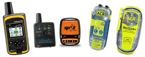
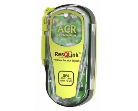
All include a 406MHz SOS transmitter, GPS receiver, 121.5MHz homing beacon and a bright strobe light l ACR resQLink l McMurdo Fast Find 220 l Ocean Signal rescueME PLB1 l
PLB cons
l Introduction l SEND satellite systems l SEND - SOS? l Tracking l
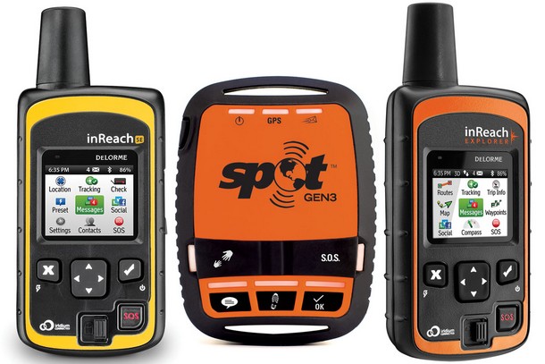
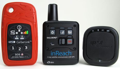
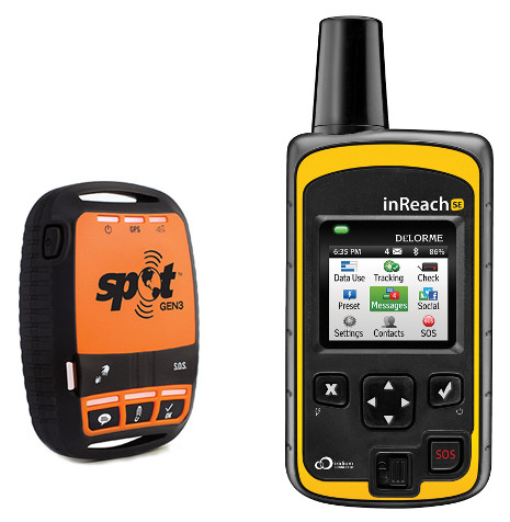
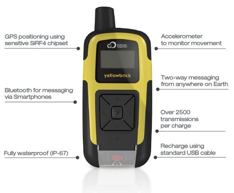
Not all SEND's transmit an SOS to a permanently staffed emergency centre. Different SENDs use different commercial satellite systems and not all satellite systems give full global coverage. The tracking and messaging options between SENDs can vary significantly. Some SENDs will only send messages (SPOT Gen 3), others will send and receive messages (Garmin/DeLorme inReach). Some devices offer mapping, others don't. Transmitter power, waterproofing and battery type all vary. Some online setup is required to use them properly and some are easier to setup than others. Even when you've chosen a specific device there will be variously priced subscription plans to decide between. The main differences are explored below by looking at the SPOT Gen 3 and the DeLorme InReach SE. Currently the 'SPOT Gen 3' costs around £105 and the 'inReach SE' £255. The SPOT uses an annual fee subscription system. DeLorme offer annual plans and a 'Freedom' option where you can subscribe a month at a time. Stop and start your service to taste. SENDs use commercial satellite networks setup for satellite phones and data communications. Garmin/DeLorme, Cerberus and YBTracking units use the Iridium system. Currently the Iridium satellite constellation offers excellent 100% global coverage. A network of 66 satellites (with 6 spares already in orbit) speed round the earth 780km up. The satellites complete an orbit of the earth in a mere 100 mins. Travelling at 17,000mph a satellite will typically cross from one horizon to the other in about 10 mins. Usually more than one satellite is visible from any point on earth, including the polar regions.
Assuming a SEND is in an area properly covered by it's network there doesn't seem to be a huge advantage of one satellite system over the other. It's easier to find online reports that favour Iridium for SENDs but I haven't found any really conclusive evidence that shows a big advantage. The design of the SEND device might affect performance more than the satellite network. Like the Cospas-Sarsat network these commercial satellite constellations are likely to evolve with time. Satellite time is precious, consequently the more a SEND accesses these commercial networks the higher the cost. SENDs usually offer an SOS or emergency function button designed to call for help. The 'help' may be official rescue services or just your friends, depending on the device.
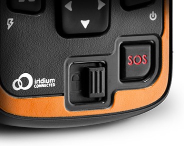
Although GEOS is a commercial outfit there is no cost to the end user. The cost is covered by the SEND manufacturers and application providers. Not all SENDs contact GEOS. The Yellowbrick YB3 from YBTracking just has an 'Alert' button. Hold this down for 5 secs and the YB3 sends a preset 'alert' message to a nominated person or group of people, by SMS text and/or email. If they're all asleep or away from their phones/PCs then you may be in trouble. The YB3 does not have a direct link to an emergency centre of any kind.
The SPOT 3, just like a PLB, cannot receive any confirmation that an SOS has been received. Similarly it can only send messages. It's a one-way only SEND. A two-way SEND can receive texts and a confirmation that an SOS has been received (InReach). All the websites I've visited suggest that a SEND SOS signal is not as reliable as a PLB SOS transmission. I've yet to find a comprehensive technical explanation of why this is, or a thorough field test which proves it. However here are three good reasons why this might well be the case. 1. SENDs use satellite systems designed for voice and data. They were not designed with emergency distress beacons in mind. The Cospas-Sarsat system was purpose built throughout, from the PLBs / EPIRBs / ELTs through to and including the satellite system. 2. If a SEND's GPS receiver cannot get a GPS fix then the SEND cannot report it's position and it can't be located. A SEND has no second option. A PLB can transmit it's GPS position and it can also be located by 'Doppler processing'. 3. SENDs use less powerful transmitters than PLBs and operate at higher frequencies. Both of these factors mean a SEND signal is more likely to be badly affected by trickier conditions ('rain fade', foliage or similar) SENDs allow a track to be shared live, on the move. Typically the SEND manufacturer will have a dedicated website where the track can be viewed on a map. Some SEND tracks can also be linked to other tracking websites like the well known LiveTrack24 and the newer XC Retrieve. Tracks generated by SPOTs and InReach devices can be displayed on both those websites. Tracking allows your position to be estimated even if the SEND is destroyed in a crash or you're unable to press a button. PLBs do not offer tracking. Satellite time is expensive, so even if a SEND can log your position every second to it's internal memory (inReach Explorer) it will transmit your position much less often. The most frequently an inReach can transmit position information is every 2 mins and the SPOT 3, 2.5 mins. In a single transmission burst a SEND may transmit several track points at once (an InReach can transmit 4). Generally, the more data transmitted the higher the cost.
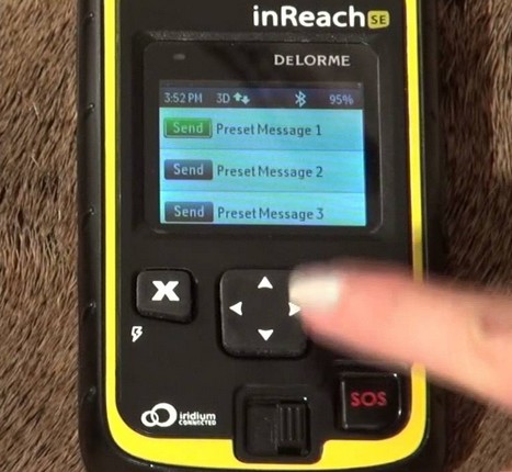
However, although not strictly 'tracking' a very useful safety feature of an inReach is the ability for it's location to be determined remotely, by a third party. Click a 'Locate' icon on the Garmin MapShare web page and the inReach unit will report it's location. It will automatically put an icon on the MapShare map. Tracking doesn't even need to be turned on. If you were badly hurt and unable to press a button, a worried friend could still find out exactly where you were. SENDs don't necessarily offer two way text communication. The SPOT 3 just has the ability to send a few preset messages and offers no confirmation that the message has reached it's destination. An inReach can send and receive text messages, allowing a proper conversation to take place. This might be really useful in an emergency. It's also very convenient for organising a complicated retrieve or explaining exactly how late home you'll be.
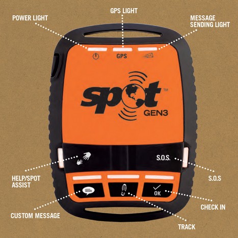
This method of sending messages is common to other SENDs as well. So it's worth looking at how SPOT messaging works before going more deeply into the inReach message capability. SOS - Under a flap, this button will start the SPOT sending an SOS every 5 minutes until the battery dies or it's cancelled. This isn't a text message as such and should only be used for serious emergencies as it alerts the GEOS emergency centre. They will send the rescue services to the transmitted position. If the SPOT is unable to get a GPS fix the transmission will still identify you and GEOS can get in touch with your registered contacts for more help.
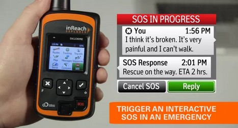
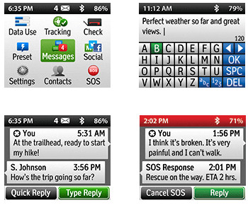
Lack of confirmation that a message has been received is not ideal and users sometimes learn after their adventure that sent messages haven't reached their nominated contacts. Rescues have been launched because OK/Check in messages weren't received. The inReach units, like the SPOT 3 have an SOS button to alert GEOS IERCC and an additional three preset messages that are easily sent. An inReach will receive confirmations for successfully sent messages.
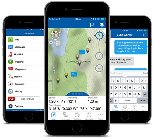
If you press the SOS button on an inReach you will get confirmation from the GEOS IERCC that the message has been received and that help is on it's way. Then it is possible to have a proper text conversation with the emergency centre and give more detail about the emergency. Even better, Garmin's app for smartphones and (Earthmate) allows full wireless control of the inReach units via bluetooth. Then the keyboard on the smartphone can be used to easily type messages.
Messages can be created on an inReach without a smartphone. The rocker switch can cursor round an on-screen keyboard. Painfully slow to produce a message, but very useful nonetheless.
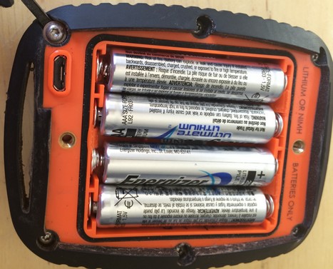
Being able to create texts on an inReach might be very useful. A firmware or OS update might have unexpectedly broken a usually reliable pairing or the smartphone might simply run out of battery. SPOT offer a SEND called the 'SPOT Connect' which also pairs with a smartphone. However the SPOT Connect has even fewer buttons than the SPOT 3 and as a standalone device only offers the SOS function. The smartphone is essential to access the full functionality of the 'Connect'. Other SENDs also offer smartphone pairing. Check that the standalone SEND does what you want without the phone. Unlike PLBs, SENDs are likely to be switched on, especially if they're being used for tracking. Although the battery life of SENDs can't compete with a PLB it is still excellent. However, a conscientious approach to batteries is needed to ensure there is always plenty of charge for SOS use. Pilot Gavin McClurg reports that the DeLorme inReach can go for 4 to 5 days of very long flights before running out of power. DeLorme claim that the inReach SE has been tested to last 100 hours, based on transmitting one track point every 10 minutes with a clear view of the sky. That allows for 8 hours tracking a day for over 12 days. The SPOT 3 will do even better and has lasted Gavin half a season. SPOT claim that the Gen 3 will last for 45 days transmitting one track point every 10 mins for 8 hours a day with a clear view of the sky. Even allowing for manufacturers optimistic claims, power is really only a concern if you're heading into the wild for an extended period.
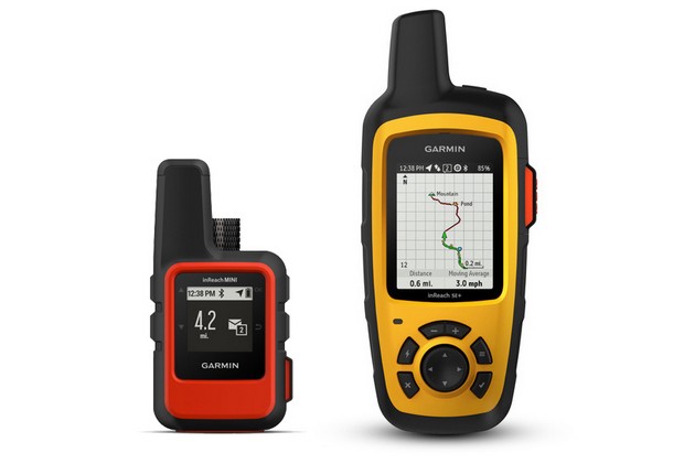
The inReach Explorer is the same size and weight as the inReach SE but adds basic GPS functionality and on screen maps. The screen is very small on the Explorer. Many pilots will already have better GPS functionality and mapping on their flight instruments and smartphones. Costing about £75 more than the inReach SE, I suspect the inReach Explorer will have a limited appeal for most pilots.
PLB manufacturers - l ACR l Kannad Marine l McMurdo l Ocean Signal l SEND manufacturers - l Cerberus l DeLorme l Garmin l SPOT l Yellowbrick l Cospas Sarsat organisation (PLBs) NOAA-SARSAT - Search and Rescue Satellite Aided Tracking (PLBs) RAF Search and Rescue - ARCC and Cospas Sarsat MCC (PLBs) Iridium satellite system (SENDs) l Globalstar satellite system (SENDs) GEOS International Emergency Response Coordination Centre (SENDs) Model reviews and comparisons DeLorme vs SPOT - Gavin McClurg (2015) l John Nestler compare (2015) Satellite Tracking - Free Aero magazine looks at options (2015) Expedition Portal (2014) - Test several new PLBs and SENDs Garmin inReach mini: in-depth review by DC Rainmaker (2018)
OutdoorLab compare units (2018) - inReach mini, SPOT Gen3, OceanSignal PLB1 DeLorme inReach SE review (2015) - OutdoorLab Back Country Chronicles - PLB comparisons - McMurdo & three ACR models Back Country Chronicles - SPOT and DeLorme inReach compared with two PLBs SPOT3 review (2013) - Section Hiker
Yellowbrick YB3 (2013) - BushWalkingBlog review Information and Discussion PG Forum - Personal trackers. SPOT, inReach etc PG Forum - Alternatives to SPOT, DeLorme and DSX? Back Country Chronicles - Are Satellite Messengers a Good Alternative for PLBs? PLBs and Satellite Messengers: How to Choose - REI MountainSafety.co.uk - PLBs l Satellite messengers l PLBs vs Satellite Messengers OceanMedix - about 406MHz PLBs
|
|
|---|---|---|